La Blanca geodata
La Blanca (Hidalgo) is a populated place; located in Mexico in America/Mexico_City (GMT-6) time zone. With population of 665 people, there are 13061 cities with bigger population in this country. Compared to other cities in Mexico, 64.9% of cities are located further ↓South; 50.3% of cities are located further →East and 70.2% of cities have lower elevation than La Blanca. Note1


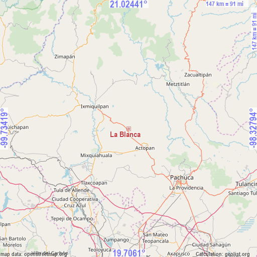
La Blanca GPS coordinates[2]
20° 21' 59.976" North, 99° 1' 51.816" West
| Map corner | latitude | longitude |
|---|---|---|
| Upper-left | 21.02441°, | -99.73419° |
| Center: | 20.36666°, | -99.03106° |
| Lower-right: | 19.7061°, | -98.32794° |
| Map W x H: | 146.6×146.6 km | = 91.1×91.1mi |
| max Lat: | 32.7° ⇑35.1% North |
| La Blanca: | 20.36666° |
| min Lat: | ⇓64.9% South 14.53588° |
| min Long | La Blanca | max Long |
| -117.105° | -99.03106° | -86.73105° |
| W 49.7%⇐ | ⇒50.3% E |
Elevation
Elevation of La Blanca is 1929 m = 6329 ft, and this is 675.3 m = 2216 ft above average elevation for this country.
| Max E: |
3497 m = 11473 ft | 29.8% |
| La Blanca | 1929 m 6329 ft | |
| Avg. | 1253.7 m = 4113 ft | |
Min E: |
-1 m = -3 ft | 70.2% |
See also: Mexico elevation on elevation.city.
Geographical zone
La Blanca is located in North Torrid zone (between Equator and Tropic of Cancer). Distance of this Northern Tropic circle is 341.4 km =212.1 mi to North.| Distance of | km | miles | from La Blanca |
|---|---|---|---|
| North Pole | 7742.5 | 4811 | to North |
| Arctic Circle | 5136.6 | 3191.7 | to North |
| Tropic Cancer | 341.4 | 212.1 | to North |
| Equator | 2264.6 | 1407.2 | to South |


Nearby cities:
15 places around La Blanca: (largest is in red/bold)
• Bominthza
6.9 km =4.3 mi,  160°
160°
• Boxaxni
3.5 km =2.2 mi,  231°
231°
• Caxuxi
8 km =5 mi,  148°
148°
• Cañada Grande
6.3 km =3.9 mi, 155°
• Cerritos
2.5 km =1.6 mi,  127°
127°
• Demacú
6.9 km =4.3 mi,  179°
179°
• Déxtho de Victoria
4.7 km =2.9 mi,  170°
170°
• El Mezquital
1.3 km =0.8 mi,  55°
55°
• González Ortega
4.8 km =3 mi,  88°
88°
• Guerrero
2.5 km =1.6 mi, 89°
• Lagunilla
2.7 km =1.7 mi, 171°
• Patria Nueva
2.2 km =1.4 mi,  284°
284°
• Santiago de Anaya
7.1 km =4.4 mi,  74°
74°
• Teofani
5 km =3.1 mi,  194°
194°
• Yolotepec
5 km =3.1 mi,  298°
298°
Sources, notices
• [Note1] Compared only with cities in Mexico existing in our database
• [Src1] Map data: © OpenStreetMap contributors (CC-BY-SA)
• [Src2] Other city data from geonames.org with taken over terms of usage.
• [Src3] Geographical zone / Annual Mean Temperature by Robert A. Rohde @ Wikipedia
