Yolotepec geodata
Yolotepec (Hidalgo) is a populated place; located in Mexico in America/Mexico_City (GMT-6) time zone. With population of 2,487 people, there are 3552 cities with bigger population in this country. Compared to other cities in Mexico, 65.3% of cities are located further ↓South; 50.8% of cities are located further →East and 70.4% of cities have lower elevation than Yolotepec. Note1


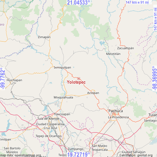
Yolotepec GPS coordinates[2]
20° 23' 15.612" North, 99° 4' 23.052" West
| Map corner | latitude | longitude |
|---|---|---|
| Upper-left | 21.04533°, | -99.7762° |
| Center: | 20.38767°, | -99.07307° |
| Lower-right: | 19.72719°, | -98.36995° |
| Map W x H: | 146.6×146.6 km | = 91.1×91.1mi |
| max Lat: | 32.7° ⇑34.7% North |
| Yolotepec: | 20.38767° |
| min Lat: | ⇓65.3% South 14.53588° |
| min Long | Yolotepec | max Long |
| -117.105° | -99.07307° | -86.73105° |
| W 49.2%⇐ | ⇒50.8% E |
Elevation
Elevation of Yolotepec is 1931 m = 6335 ft, and this is 677.3 m = 2222 ft above average elevation for this country.
| Max E: |
3497 m = 11473 ft | 29.6% |
| Yolotepec | 1931 m 6335 ft | |
| Avg. | 1253.7 m = 4113 ft | |
Min E: |
-1 m = -3 ft | 70.4% |
See also: Mexico elevation on elevation.city.
Geographical zone
Yolotepec is located in North Torrid zone (between Equator and Tropic of Cancer). Distance of this Northern Tropic circle is 339 km =210.6 mi to North.| Distance of | km | miles | from Yolotepec |
|---|---|---|---|
| North Pole | 7740.2 | 4809.5 | to North |
| Arctic Circle | 5134.3 | 3190.3 | to North |
| Tropic Cancer | 339 | 210.6 | to North |
| Equator | 2266.9 | 1408.6 | to South |


Nearby cities:
15 places around Yolotepec: (largest is in red/bold)
• Boxaxni
4.8 km =3 mi,  159°
159°
• Cañada Chica
9.1 km =5.7 mi,  288°
288°
• Cerritos
7.4 km =4.6 mi,  121°
121°
• Déxtho de Victoria
8.6 km =5.3 mi,  143°
143°
• El Mezquital
5.7 km =3.5 mi,  106°
106°
• Ex- Hacienda de Ocotza
4.9 km =3 mi,  331°
331°
• González Ortega
9.4 km =5.8 mi,  103°
103°
• Guerrero
7.2 km =4.5 mi, 108°
• Julián Villagrán
3.4 km =2.1 mi, 286°
• La Blanca
5 km =3.1 mi, 118°
• Lagunilla
6.9 km =4.3 mi, 136°
• Patria Nueva
2.9 km =1.8 mi,  128°
128°
• Taxadho
9.4 km =5.8 mi,  302°
302°
• Teofani
7.9 km =4.9 mi, 156°
• Xuchitlán
8.3 km =5.2 mi,  270°
270°
Sources, notices
• [Note1] Compared only with cities in Mexico existing in our database
• [Src1] Map data: © OpenStreetMap contributors (CC-BY-SA)
• [Src2] Other city data from geonames.org with taken over terms of usage.
• [Src3] Geographical zone / Annual Mean Temperature by Robert A. Rohde @ Wikipedia
