Lagunilla geodata
Lagunilla (Hidalgo) is a populated place; located in Mexico in America/Mexico_City (GMT-6) time zone. With population of 1,596 people, there are 5414 cities with bigger population in this country. Compared to other cities in Mexico, 64.4% of cities are located further ↓South; 50.2% of cities are located further →East and 70.4% of cities have lower elevation than Lagunilla. Note1


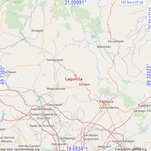
Lagunilla GPS coordinates[2]
20° 20' 35.016" North, 99° 1' 38.532" West
| Map corner | latitude | longitude |
|---|---|---|
| Upper-left | 21.00091°, | -99.7305° |
| Center: | 20.34306°, | -99.02737° |
| Lower-right: | 19.6824°, | -98.32425° |
| Map W x H: | 146.6×146.6 km | = 91.1×91.1mi |
| max Lat: | 32.7° ⇑35.6% North |
| Lagunilla: | 20.34306° |
| min Lat: | ⇓64.4% South 14.53588° |
| min Long | Lagunilla | max Long |
| -117.105° | -99.02737° | -86.73105° |
| W 49.8%⇐ | ⇒50.2% E |
Elevation
Elevation of Lagunilla is 1932 m = 6339 ft, and this is 678.3 m = 2225 ft above average elevation for this country.
| Max E: |
3497 m = 11473 ft | 29.6% |
| Lagunilla | 1932 m 6339 ft | |
| Avg. | 1253.7 m = 4113 ft | |
Min E: |
-1 m = -3 ft | 70.4% |
See also: Mexico elevation on elevation.city.
Geographical zone
Lagunilla is located in North Torrid zone (between Equator and Tropic of Cancer). Distance of this Northern Tropic circle is 344 km =213.8 mi to North.| Distance of | km | miles | from Lagunilla |
|---|---|---|---|
| North Pole | 7745.1 | 4812.6 | to North |
| Arctic Circle | 5139.2 | 3193.3 | to North |
| Tropic Cancer | 344 | 213.8 | to North |
| Equator | 2261.9 | 1405.5 | to South |


Nearby cities:
15 places around Lagunilla: (largest is in red/bold)
• Bominthza
4.3 km =2.7 mi,  154°
154°
• Boxaxni
3.1 km =1.9 mi,  278°
278°
• Caxuxi
5.7 km =3.5 mi,  137°
137°
• Cañada Grande
3.8 km =2.4 mi, 144°
• Cerritos
1.9 km =1.2 mi,  54°
54°
• Demacú
4.2 km =2.6 mi,  183°
183°
• Déxtho de Victoria
2 km =1.2 mi,  169°
169°
• El Bondho
6.8 km =4.2 mi,  159°
159°
• El Mezquital
3.4 km =2.1 mi,  11°
11°
• González Ortega
5.2 km =3.2 mi,  57°
57°
• Guerrero
3.4 km =2.1 mi,  37°
37°
• La Blanca
2.7 km =1.7 mi,  351°
351°
• Patria Nueva
4.1 km =2.5 mi,  321°
321°
• San Salvador
6.5 km =4 mi, 168°
• Teofani
2.8 km =1.7 mi,  215°
215°
Sources, notices
• [Note1] Compared only with cities in Mexico existing in our database
• [Src1] Map data: © OpenStreetMap contributors (CC-BY-SA)
• [Src2] Other city data from geonames.org with taken over terms of usage.
• [Src3] Geographical zone / Annual Mean Temperature by Robert A. Rohde @ Wikipedia
