Ignacio López Rayón geodata
Ignacio López Rayón (Hidalgo) is a populated place; located in Mexico in America/Mexico_City (GMT-6) time zone. With population of 526 people, there are 16064 cities with bigger population in this country. Compared to other cities in Mexico, 67.5% of cities are located further ↓South; 53.9% of cities are located further →East and 60.7% of cities have lower elevation than Ignacio López Rayón. Note1


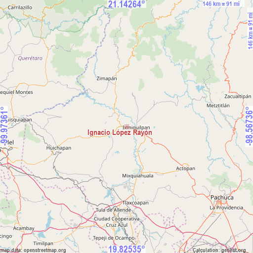
Ignacio López Rayón GPS coordinates[2]
20° 29' 7.476" North, 99° 16' 13.728" West
| Map corner | latitude | longitude |
|---|---|---|
| Upper-left | 21.14264°, | -99.97361° |
| Center: | 20.48541°, | -99.27048° |
| Lower-right: | 19.82535°, | -98.56736° |
| Map W x H: | 146.5×146.5 km | = 91×91mi |
| max Lat: | 32.7° ⇑32.5% North |
| Ignacio López Rayón: | 20.48541° |
| min Lat: | ⇓67.5% South 14.53588° |
| min Long | Ignacio López | max Long |
| -117.105° | -99.27048° | -86.73105° |
| W 46.1%⇐ | ⇒53.9% E |
Elevation
Elevation of Ignacio López Rayón is 1739 m = 5705 ft, and this is 485.3 m = 1592 ft above average elevation for this country.
| Max E: |
3497 m = 11473 ft | 39.3% |
| Ignacio López Rayón | 1739 m 5705 ft | |
| Avg. | 1253.7 m = 4113 ft | |
Min E: |
-1 m = -3 ft | 60.7% |
See also: Mexico elevation on elevation.city.
Geographical zone
Ignacio López Rayón is located in North Torrid zone (between Equator and Tropic of Cancer). Distance of this Northern Tropic circle is 328.2 km =203.9 mi to North.| Distance of | km | miles | from Ignacio López Rayón |
|---|---|---|---|
| North Pole | 7729.3 | 4802.8 | to North |
| Arctic Circle | 5123.4 | 3183.5 | to North |
| Tropic Cancer | 328.2 | 203.9 | to North |
| Equator | 2277.8 | 1415.4 | to South |


Nearby cities:
15 places around Ignacio López Rayón: (largest is in red/bold)
• Bondhí
5.9 km =3.7 mi,  333°
333°
• Cantinela
7 km =4.3 mi,  116°
116°
• El Carrizal
7 km =4.3 mi,  77°
77°
• El Deca
1.2 km =0.7 mi,  224°
224°
• El Durazno
7.4 km =4.6 mi,  45°
45°
• El Déxtho
2.1 km =1.3 mi,  5°
5°
• El Mandhó
3.8 km =2.4 mi,  61°
61°
• Ixmiquilpan
5.6 km =3.5 mi,  97°
97°
• Juchitlán
7.2 km =4.5 mi,  345°
345°
• La Heredad
5.1 km =3.2 mi, 52°
• La Vega
6.2 km =3.9 mi,  276°
276°
• Panales
1.8 km =1.1 mi,  167°
167°
• Portezuelo
3.7 km =2.3 mi,  272°
272°
• San Juanico
6.1 km =3.8 mi,  27°
27°
• Santiago Ixtlahuaca
5.5 km =3.4 mi,  285°
285°
Sources, notices
• [Note1] Compared only with cities in Mexico existing in our database
• [Src1] Map data: © OpenStreetMap contributors (CC-BY-SA)
• [Src2] Other city data from geonames.org with taken over terms of usage.
• [Src3] Geographical zone / Annual Mean Temperature by Robert A. Rohde @ Wikipedia
