El Déxtho geodata
El Déxtho (Hidalgo) is a populated place; located in Mexico in America/Mexico_City (GMT-6) time zone. With population of 590 people, there are 14554 cities with bigger population in this country. Compared to other cities in Mexico, 67.9% of cities are located further ↓South; 53.9% of cities are located further →East and 61% of cities have lower elevation than El Déxtho. Note1


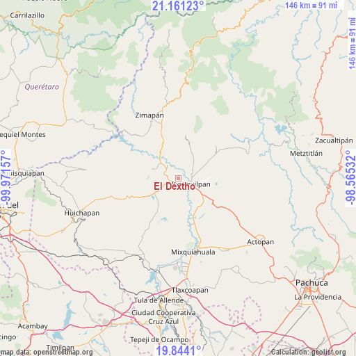
El Déxtho GPS coordinates[2]
20° 30' 14.688" North, 99° 16' 6.384" West
| Map corner | latitude | longitude |
|---|---|---|
| Upper-left | 21.16123°, | -99.97157° |
| Center: | 20.50408°, | -99.26844° |
| Lower-right: | 19.8441°, | -98.56532° |
| Map W x H: | 146.5×146.5 km | = 91×91mi |
| max Lat: | 32.7° ⇑32.1% North |
| El Déxtho: | 20.50408° |
| min Lat: | ⇓67.9% South 14.53588° |
| min Long | El Déxtho | max Long |
| -117.105° | -99.26844° | -86.73105° |
| W 46.1%⇐ | ⇒53.9% E |
Elevation
Elevation of El Déxtho is 1743 m = 5719 ft, and this is 489.3 m = 1605 ft above average elevation for this country.
| Max E: |
3497 m = 11473 ft | 39% |
| El Déxtho | 1743 m 5719 ft | |
| Avg. | 1253.7 m = 4113 ft | |
Min E: |
-1 m = -3 ft | 61% |
See also: Mexico elevation on elevation.city.
Geographical zone
El Déxtho is located in North Torrid zone (between Equator and Tropic of Cancer). Distance of this Northern Tropic circle is 326.1 km =202.6 mi to North.| Distance of | km | miles | from El Déxtho |
|---|---|---|---|
| North Pole | 7727.2 | 4801.5 | to North |
| Arctic Circle | 5121.3 | 3182.2 | to North |
| Tropic Cancer | 326.1 | 202.6 | to North |
| Equator | 2279.8 | 1416.6 | to South |


Nearby cities:
15 places around El Déxtho: (largest is in red/bold)
• Bondhí
4.2 km =2.6 mi,  318°
318°
• El Carrizal
6.7 km =4.2 mi,  94°
94°
• El Deca
3.1 km =1.9 mi,  200°
200°
• El Durazno
5.9 km =3.7 mi,  58°
58°
• El Mandhó
3.2 km =2 mi, 94°
• Ignacio López Rayón
2.1 km =1.3 mi,  185°
185°
• Ixmiquilpan
6.1 km =3.8 mi,  118°
118°
• Juchitlán
5.3 km =3.3 mi,  337°
337°
• La Heredad
3.9 km =2.4 mi,  75°
75°
• La Vega
6.5 km =4 mi,  257°
257°
• Panales
3.8 km =2.4 mi,  177°
177°
• Portezuelo
4.4 km =2.7 mi,  243°
243°
• San Juanico
4.2 km =2.6 mi,  38°
38°
• Santiago Ixtlahuaca
5.5 km =3.4 mi, 263°
• Tasquillo
6.8 km =4.2 mi, 316°
Sources, notices
• [Note1] Compared only with cities in Mexico existing in our database
• [Src1] Map data: © OpenStreetMap contributors (CC-BY-SA)
• [Src2] Other city data from geonames.org with taken over terms of usage.
• [Src3] Geographical zone / Annual Mean Temperature by Robert A. Rohde @ Wikipedia
