Santiago Tlajomulco geodata
Santiago Tlajomulco (Morelos) is a populated place; located in Mexico in America/Mexico_City (GMT-6) time zone. With population of 927 people, there are 9410 cities with bigger population in this country. Compared to other cities in Mexico, 56.7% of cities are located further ↓South; 51.7% of cities are located further ←West and 90.8% of cities have lower elevation than Santiago Tlajomulco. Note1


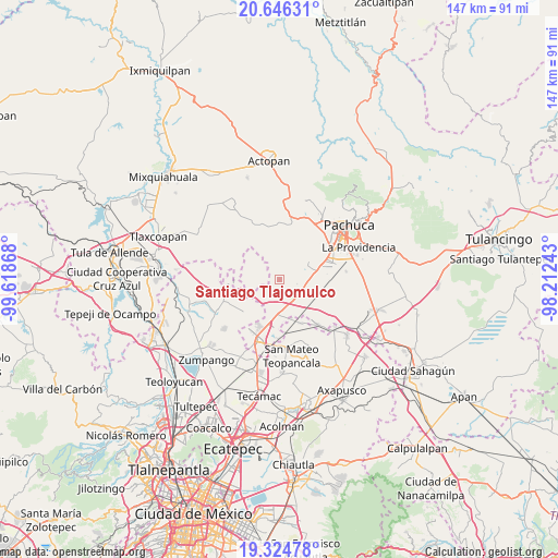
Santiago Tlajomulco GPS coordinates[2]
19° 59' 12.948" North, 98° 54' 55.98" West
| Map corner | latitude | longitude |
|---|---|---|
| Upper-left | 20.64631°, | -99.61868° |
| Center: | 19.98693°, | -98.91555° |
| Lower-right: | 19.32478°, | -98.21243° |
| Map W x H: | 146.9×146.9 km | = 91.3×91.3mi |
| max Lat: | 32.7° ⇑43.3% North |
| Santiago Tlajomulco: | 19.98693° |
| min Lat: | ⇓56.7% South 14.53588° |
| min Long | Santiago Tlajom | max Long |
| -117.105° | -98.91555° | -86.73105° |
| W 51.7%⇐ | ⇒48.3% E |
Elevation
Elevation of Santiago Tlajomulco is 2435 m = 7989 ft, and this is 1181.3 m = 3876 ft above average elevation for this country.
| Max E: |
3497 m = 11473 ft | 9.2% |
| Santiago Tlajomulco | 2435 m 7989 ft | |
| Avg. | 1253.7 m = 4113 ft | |
Min E: |
-1 m = -3 ft | 90.8% |
See also: Mexico elevation on elevation.city.
Geographical zone
Santiago Tlajomulco is located in North Torrid zone (between Equator and Tropic of Cancer). Distance of this Northern Tropic circle is 383.6 km =238.4 mi to North.| Distance of | km | miles | from Santiago Tlajomulco |
|---|---|---|---|
| North Pole | 7784.7 | 4837.2 | to North |
| Arctic Circle | 5178.8 | 3218 | to North |
| Tropic Cancer | 383.6 | 238.4 | to North |
| Equator | 2222.3 | 1380.9 | to South |


Nearby cities:
15 places around Santiago Tlajomulco: (largest is in red/bold)
• Acayuca
8.9 km =5.5 mi,  61°
61°
• Colonia Nueva Tlaxiaca
8 km =5 mi, 55°
• Don Antonio
12.7 km =7.9 mi,  189°
189°
• El Carmen
11.8 km =7.3 mi,  201°
201°
• El Mirador
12 km =7.5 mi,  66°
66°
• General Felipe Ángeles (Los Ángeles)
10 km =6.2 mi, 186°
• La Gloria
8.9 km =5.5 mi,  269°
269°
• Las Pintas
10.5 km =6.5 mi,  163°
163°
• Olmos
12 km =7.5 mi, 185°
• Oriental de Zapata
12.1 km =7.5 mi, 269°
• San Francisco Zacacalco
9.6 km =6 mi,  227°
227°
• San Pedro Huaquilpan
5 km =3.1 mi,  88°
88°
• Tolcayuca
3.2 km =2 mi, 187°
• Vicente Guerrero (San Javier)
4.4 km =2.7 mi, 160°
• Zapotlán de Juárez
5.5 km =3.4 mi,  101°
101°
Sources, notices
• [Note1] Compared only with cities in Mexico existing in our database
• [Src1] Map data: © OpenStreetMap contributors (CC-BY-SA)
• [Src2] Other city data from geonames.org with taken over terms of usage.
• [Src3] Geographical zone / Annual Mean Temperature by Robert A. Rohde @ Wikipedia
