Tolcayuca geodata
Tolcayuca (Hidalgo) is a seat of a second-order administrative division; located in Mexico in America/Mexico_City (GMT-6) time zone. With population of 6,836 people, there are 1366 cities with bigger population in this country. Compared to other cities in Mexico, 56.1% of cities are located further ↓South; 51.7% of cities are located further ←West and 89.5% of cities have lower elevation than Tolcayuca. Note1


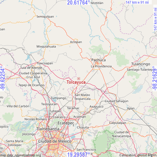
Tolcayuca GPS coordinates[2]
19° 57' 29.304" North, 98° 55' 9.876" West
| Map corner | latitude | longitude |
|---|---|---|
| Upper-left | 20.61764°, | -99.62254° |
| Center: | 19.95814°, | -98.91941° |
| Lower-right: | 19.29587°, | -98.21629° |
| Map W x H: | 147×147 km | = 91.3×91.3mi |
| max Lat: | 32.7° ⇑43.9% North |
| Tolcayuca: | 19.95814° |
| min Lat: | ⇓56.1% South 14.53588° |
| min Long | Tolcayuca | max Long |
| -117.105° | -98.91941° | -86.73105° |
| W 51.7%⇐ | ⇒48.3% E |
Elevation
Elevation of Tolcayuca is 2388 m = 7835 ft, and this is 1134.3 m = 3721 ft above average elevation for this country.
| Max E: |
3497 m = 11473 ft | 10.5% |
| Tolcayuca | 2388 m 7835 ft | |
| Avg. | 1253.7 m = 4113 ft | |
Min E: |
-1 m = -3 ft | 89.5% |
See also: Mexico elevation on elevation.city.
Geographical zone
Tolcayuca is located in North Torrid zone (between Equator and Tropic of Cancer). Distance of this Northern Tropic circle is 386.8 km =240.3 mi to North.| Distance of | km | miles | from Tolcayuca |
|---|---|---|---|
| North Pole | 7787.9 | 4839.2 | to North |
| Arctic Circle | 5182 | 3219.9 | to North |
| Tropic Cancer | 386.8 | 240.3 | to North |
| Equator | 2219.1 | 1378.9 | to South |


Nearby cities:
15 places around Tolcayuca: (largest is in red/bold)
• Colonia Nueva Tlaxiaca
10.4 km =6.5 mi,  41°
41°
• Don Antonio
9.4 km =5.8 mi,  189°
189°
• El Carmen
8.8 km =5.5 mi,  206°
206°
• El Cid
10.1 km =6.3 mi,  184°
184°
• General Felipe Ángeles (Los Ángeles)
6.8 km =4.2 mi, 185°
• Ixtlahuaca de Cuauhtémoc
10.5 km =6.5 mi,  144°
144°
• La Gloria
9 km =5.6 mi,  290°
290°
• Las Pintas
7.6 km =4.7 mi,  153°
153°
• Las Plazas
10.1 km =6.3 mi, 194°
• Olmos
8.8 km =5.5 mi, 185°
• San Francisco Zacacalco
7.4 km =4.6 mi,  243°
243°
• San Pedro Huaquilpan
6.4 km =4 mi,  58°
58°
• Santiago Tlajomulco
3.2 km =2 mi,  7°
7°
• Vicente Guerrero (San Javier)
2.1 km =1.3 mi,  115°
115°
• Zapotlán de Juárez
6.1 km =3.8 mi,  69°
69°
Sources, notices
• [Note1] Compared only with cities in Mexico existing in our database
• [Src1] Map data: © OpenStreetMap contributors (CC-BY-SA)
• [Src2] Other city data from geonames.org with taken over terms of usage.
• [Src3] Geographical zone / Annual Mean Temperature by Robert A. Rohde @ Wikipedia
