San Simón Tlatlahuquitepec geodata
San Simón Tlatlahuquitepec (Tlaxcala) is a populated place; located in Mexico in America/Mexico_City (GMT-6) time zone. With population of 2,817 people, there are 3151 cities with bigger population in this country. Compared to other cities in Mexico, 56.3% of cities are located further ↑North; 60.9% of cities are located further ←West and 93.5% of cities have lower elevation than San Simón Tlatlahuquitepec. Note1
Current local time in San Simón Tlatlahuquitepec:
12:57 AM, WednesdayDifference from your time zone: hours


San Simón Tlatlahuquitepec GPS coordinates[2]
19° 23' 54.312" North, 98° 13' 26.256" West
| Map corner | latitude | longitude |
|---|---|---|
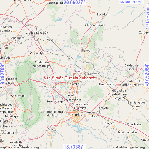
| Upper-left | 20.06027°, | -98.92709° |
| Center: | 19.39842°, | -98.22396° |
| Lower-right: | 18.73387°, | -97.52084° |
| Map W x H: | 147.5×147.5 km | = 91.7×91.7mi |
| max Lat: | 32.7° ⇑56.3% North |
| San Simón Tlatlahuquitepec: | 19.39842° |
| min Lat: | ⇓43.7% South 14.53588° |
| min Long | San Simón Tlat | max Long |
| -117.105° | -98.22396° | -86.73105° |
| W 60.9%⇐ | ⇒39.1% E |
Elevation
Elevation of San Simón Tlatlahuquitepec is 2551 m = 8369 ft, and this is 1297.3 m = 4256 ft above average elevation for this country.
| Max E: |
3497 m = 11473 ft | 6.5% |
| San Simón Tlatlahuquitepec | 2551 m 8369 ft | |
| Avg. | 1253.7 m = 4113 ft | |
Min E: |
-1 m = -3 ft | 93.5% |
See also: Mexico elevation on elevation.city.
Geographical zone
San Simón Tlatlahuquitepec is located in North Torrid zone (between Equator and Tropic of Cancer). Distance of this Northern Tropic circle is 449 km =279 mi to North.| Distance of | km | miles | from San Simón Tlatlahuquitepec |
|---|---|---|---|
| North Pole | 7850.2 | 4877.9 | to North |
| Arctic Circle | 5244.3 | 3258.7 | to North |
| Tropic Cancer | 449 | 279 | to North |
| Equator | 2156.9 | 1340.2 | to South |


Nearby cities:
15 places around San Simón Tlatlahuquitepec: (largest is in red/bold)
• Barrio de Atencingo
5.4 km =3.4 mi,  93°
93°
• Barrio de Cuatla
5.1 km =3.2 mi,  10°
10°
• Belén Atzitzimititlán
6.7 km =4.2 mi,  148°
148°
• Hualcaltzinco
6.7 km =4.2 mi, 87°
• Huiloapan
5 km =3.1 mi,  254°
254°
• San Ambrosio Texantla
5.9 km =3.7 mi,  215°
215°
• San Benito Xaltocan
6 km =3.7 mi,  82°
82°
• San Francisco Tlacuilohcan
3.3 km =2.1 mi, 83°
• San Matías Tepetomatitlán
5.8 km =3.6 mi, 148°
• Santa Bárbara Acuicultzcatepec
5.3 km =3.3 mi,  359°
359°
• Santa María Atlihuetzian
5.4 km =3.4 mi,  116°
116°
• Topilco de Juárez
3.6 km =2.2 mi,  45°
45°
• Xaltocan
3.2 km =2 mi,  26°
26°
• Yauhquemehcan
4.5 km =2.8 mi, 77°
• Zimatepec
6.7 km =4.2 mi,  67°
67°
Sources, notices
• [Note1] Compared only with cities in Mexico existing in our database
• [Src1] Map data: © OpenStreetMap contributors (CC-BY-SA)
• [Src2] Other city data from geonames.org with taken over terms of usage.
• [Src3] Geographical zone / Annual Mean Temperature by Robert A. Rohde @ Wikipedia
