San Matías Tepetomatitlán geodata
San Matías Tepetomatitlán (Tlaxcala) is a populated place; located in Mexico in America/Mexico_City (GMT-6) time zone. With population of 2,338 people, there are 3775 cities with bigger population in this country. Compared to other cities in Mexico, 57.5% of cities are located further ↑North; 61.3% of cities are located further ←West and 87.9% of cities have lower elevation than San Matías Tepetomatitlán. Note1
Current local time in San Matías Tepetomatitlán:
05:06 AM, WednesdayDifference from your time zone: hours


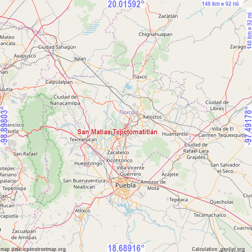
San Matías Tepetomatitlán GPS coordinates[2]
19° 21' 14.004" North, 98° 11' 41.64" West
| Map corner | latitude | longitude |
|---|---|---|
| Upper-left | 20.01592°, | -98.89803° |
| Center: | 19.35389°, | -98.1949° |
| Lower-right: | 18.68916°, | -97.49178° |
| Map W x H: | 147.5×147.5 km | = 91.7×91.7mi |
| max Lat: | 32.7° ⇑57.5% North |
| San Matías Tepetomatitlán: | 19.35389° |
| min Lat: | ⇓42.5% South 14.53588° |
| min Long | San Matías Tep | max Long |
| -117.105° | -98.1949° | -86.73105° |
| W 61.3%⇐ | ⇒38.7% E |
Elevation
Elevation of San Matías Tepetomatitlán is 2339 m = 7674 ft, and this is 1085.3 m = 3561 ft above average elevation for this country.
| Max E: |
3497 m = 11473 ft | 12.1% |
| San Matías Tepetomatitlán | 2339 m 7674 ft | |
| Avg. | 1253.7 m = 4113 ft | |
Min E: |
-1 m = -3 ft | 87.9% |
See also: Mexico elevation on elevation.city.
Geographical zone
San Matías Tepetomatitlán is located in North Torrid zone (between Equator and Tropic of Cancer). Distance of this Northern Tropic circle is 454 km =282.1 mi to North.| Distance of | km | miles | from San Matías Tepetomatitlán |
|---|---|---|---|
| North Pole | 7855.1 | 4880.9 | to North |
| Arctic Circle | 5249.2 | 3261.7 | to North |
| Tropic Cancer | 454 | 282.1 | to North |
| Equator | 2152 | 1337.2 | to South |


Nearby cities:
15 places around San Matías Tepetomatitlán: (largest is in red/bold)
• Amaxac de Guerrero
2.7 km =1.7 mi,  107°
107°
• Apetatitlán Antonio Carbajal
2.6 km =1.6 mi,  139°
139°
• Belén Atzitzimititlán
0.9 km =0.6 mi,  146°
146°
• Contla
4.1 km =2.5 mi,  132°
132°
• La Candelaria Teotlalpan
4 km =2.5 mi,  234°
234°
• San Buenaventura Atempan
4.1 km =2.5 mi,  223°
223°
• San Esteban Tizatlán
2.6 km =1.6 mi, 230°
• San José Tepoxtla
5 km =3.1 mi,  52°
52°
• Santa Cruz Tlaxcala
4.6 km =2.9 mi,  88°
88°
• Santa María Atlihuetzian
3.1 km =1.9 mi,  35°
35°
• Santa María Ixtulco
3.5 km =2.2 mi,  204°
204°
• Santiago Tepeticpac
4 km =2.5 mi,  237°
237°
• Tecolotla
1.9 km =1.2 mi, 151°
• Tlatempan
2.6 km =1.6 mi, 199°
• Tlaxcala
3.9 km =2.4 mi,  187°
187°
Sources, notices
• [Note1] Compared only with cities in Mexico existing in our database
• [Src1] Map data: © OpenStreetMap contributors (CC-BY-SA)
• [Src2] Other city data from geonames.org with taken over terms of usage.
• [Src3] Geographical zone / Annual Mean Temperature by Robert A. Rohde @ Wikipedia
