Toluca de Guadalupe geodata
Toluca de Guadalupe (Tlaxcala) is a populated place; located in Mexico in America/Mexico_City (GMT-6) time zone. With population of 3,133 people, there are 2883 cities with bigger population in this country. Compared to other cities in Mexico, 54.7% of cities are located further ↑North; 64.2% of cities are located further ←West and 96.6% of cities have lower elevation than Toluca de Guadalupe. Note1


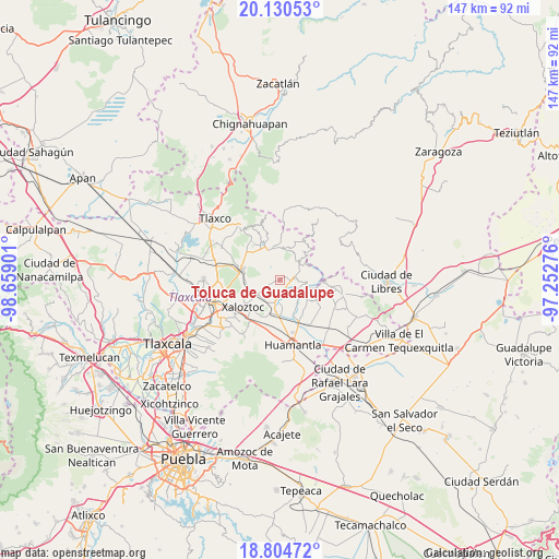
Toluca de Guadalupe GPS coordinates[2]
19° 28' 8.328" North, 97° 57' 21.168" West
| Map corner | latitude | longitude |
|---|---|---|
| Upper-left | 20.13053°, | -98.65901° |
| Center: | 19.46898°, | -97.95588° |
| Lower-right: | 18.80472°, | -97.25276° |
| Map W x H: | 147.4×147.4 km | = 91.6×91.6mi |
| max Lat: | 32.7° ⇑54.7% North |
| Toluca de Guadalupe: | 19.46898° |
| min Lat: | ⇓45.3% South 14.53588° |
| min Long | Toluca de Guada | max Long |
| -117.105° | -97.95588° | -86.73105° |
| W 64.2%⇐ | ⇒35.8% E |
Elevation
Elevation of Toluca de Guadalupe is 2656 m = 8714 ft, and this is 1402.3 m = 4601 ft above average elevation for this country.
| Max E: |
3497 m = 11473 ft | 3.4% |
| Toluca de Guadalupe | 2656 m 8714 ft | |
| Avg. | 1253.7 m = 4113 ft | |
Min E: |
-1 m = -3 ft | 96.6% |
See also: Mexico elevation on elevation.city.
Geographical zone
Toluca de Guadalupe is located in North Torrid zone (between Equator and Tropic of Cancer). Distance of this Northern Tropic circle is 441.2 km =274.1 mi to North.| Distance of | km | miles | from Toluca de Guadalupe |
|---|---|---|---|
| North Pole | 7842.3 | 4873 | to North |
| Arctic Circle | 5236.4 | 3253.7 | to North |
| Tropic Cancer | 441.2 | 274.1 | to North |
| Equator | 2164.7 | 1345.1 | to South |


Nearby cities:
15 places around Toluca de Guadalupe: (largest is in red/bold)
• Colonia José López Portillo
11.1 km =6.9 mi,  246°
246°
• Colonia Velazco
7.5 km =4.7 mi,  234°
234°
• Cristalaco
11.5 km =7.1 mi,  83°
83°
• El Capulín
5.5 km =3.4 mi,  112°
112°
• El Carmen Xalpatlahuaya
9 km =5.6 mi,  197°
197°
• Emiliano Zapata
10.8 km =6.7 mi,  22°
22°
• Guadalupe Victoria
3 km =1.9 mi,  160°
160°
• José María Morelos y Pavón
10.5 km =6.5 mi,  284°
284°
• La Caldera
9.7 km =6 mi,  69°
69°
• Lázaro Cárdenas
8.1 km =5 mi,  340°
340°
• Nicolás Bravo
5.4 km =3.4 mi,  193°
193°
• San José Villarreal
9.4 km =5.8 mi,  40°
40°
• Santa Cruz Zacatzontetla
11.5 km =7.1 mi, 226°
• Terrenate
3.8 km =2.4 mi, 77°
• Xaloztoc
11.6 km =7.2 mi, 234°
Sources, notices
• [Note1] Compared only with cities in Mexico existing in our database
• [Src1] Map data: © OpenStreetMap contributors (CC-BY-SA)
• [Src2] Other city data from geonames.org with taken over terms of usage.
• [Src3] Geographical zone / Annual Mean Temperature by Robert A. Rohde @ Wikipedia
