Colonia Velazco geodata
Colonia Velazco (Tlaxcala) is a populated place; located in Mexico in America/Mexico_City (GMT-6) time zone. With population of 858 people, there are 10191 cities with bigger population in this country. Compared to other cities in Mexico, 55.5% of cities are located further ↑North; 63.4% of cities are located further ←West and 92.2% of cities have lower elevation than Colonia Velazco. Note1


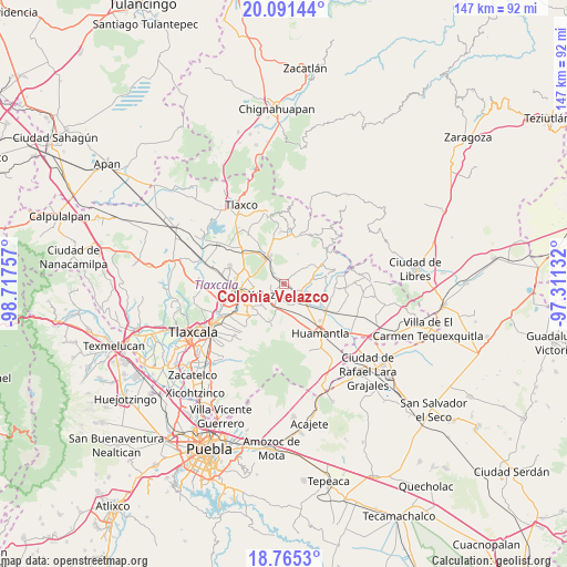
Colonia Velazco GPS coordinates[2]
19° 25' 46.992" North, 98° 0' 51.984" West
| Map corner | latitude | longitude |
|---|---|---|
| Upper-left | 20.09144°, | -98.71757° |
| Center: | 19.42972°, | -98.01444° |
| Lower-right: | 18.7653°, | -97.31132° |
| Map W x H: | 147.5×147.5 km | = 91.7×91.7mi |
| max Lat: | 32.7° ⇑55.5% North |
| Colonia Velazco: | 19.42972° |
| min Lat: | ⇓44.5% South 14.53588° |
| min Long | Colonia Velazco | max Long |
| -117.105° | -98.01444° | -86.73105° |
| W 63.4%⇐ | ⇒36.6% E |
Elevation
Elevation of Colonia Velazco is 2494 m = 8182 ft, and this is 1240.3 m = 4069 ft above average elevation for this country.
| Max E: |
3497 m = 11473 ft | 7.8% |
| Colonia Velazco | 2494 m 8182 ft | |
| Avg. | 1253.7 m = 4113 ft | |
Min E: |
-1 m = -3 ft | 92.2% |
See also: Mexico elevation on elevation.city.
Geographical zone
Colonia Velazco is located in North Torrid zone (between Equator and Tropic of Cancer). Distance of this Northern Tropic circle is 445.5 km =276.8 mi to North.| Distance of | km | miles | from Colonia Velazco |
|---|---|---|---|
| North Pole | 7846.7 | 4875.7 | to North |
| Arctic Circle | 5240.8 | 3256.5 | to North |
| Tropic Cancer | 445.5 | 276.8 | to North |
| Equator | 2160.4 | 1342.4 | to South |


Nearby cities:
15 places around Colonia Velazco: (largest is in red/bold)
• Colonia José López Portillo
4.1 km =2.5 mi,  268°
268°
• Colonia Venustiano Carranza
5.7 km =3.5 mi,  234°
234°
• El Carmen Xalpatlahuaya
5.4 km =3.4 mi,  140°
140°
• Guadalupe Texcalac
6.7 km =4.2 mi,  278°
278°
• Guadalupe Victoria
7.3 km =4.5 mi,  78°
78°
• José María Morelos y Pavón
8.1 km =5 mi,  330°
330°
• Lázaro Cárdenas
8.4 km =5.2 mi,  160°
160°
• Nicolás Bravo
5 km =3.1 mi,  99°
99°
• San Juan Quetzalcoapan
8.2 km =5.1 mi, 226°
• San Pedro Tlacotepec
5 km =3.1 mi,  221°
221°
• Santa Cruz Zacatzontetla
4.1 km =2.5 mi,  211°
211°
• Santa María Texcalac
7.6 km =4.7 mi,  264°
264°
• Tocatlán
4.8 km =3 mi,  196°
196°
• Toluca de Guadalupe
7.5 km =4.7 mi,  54°
54°
• Xaloztoc
4.1 km =2.5 mi, 233°
Sources, notices
• [Note1] Compared only with cities in Mexico existing in our database
• [Src1] Map data: © OpenStreetMap contributors (CC-BY-SA)
• [Src2] Other city data from geonames.org with taken over terms of usage.
• [Src3] Geographical zone / Annual Mean Temperature by Robert A. Rohde @ Wikipedia
