San José Villarreal geodata
San José Villarreal (Tlaxcala) is a populated place; located in Mexico in America/Mexico_City (GMT-6) time zone. With population of 1,444 people, there are 5977 cities with bigger population in this country. Compared to other cities in Mexico, 53.4% of cities are located further ↑North; 64.9% of cities are located further ←West and 99.9% of cities have lower elevation than San José Villarreal. Note1


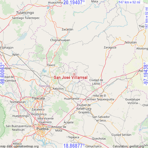
San José Villarreal GPS coordinates[2]
19° 31' 58.008" North, 97° 53' 51" West
| Map corner | latitude | longitude |
|---|---|---|
| Upper-left | 20.19407°, | -98.60063° |
| Center: | 19.53278°, | -97.8975° |
| Lower-right: | 18.86877°, | -97.19438° |
| Map W x H: | 147.4×147.4 km | = 91.6×91.6mi |
| max Lat: | 32.7° ⇑53.4% North |
| San José Villarreal: | 19.53278° |
| min Lat: | ⇓46.6% South 14.53588° |
| min Long | San José Villa | max Long |
| -117.105° | -97.8975° | -86.73105° |
| W 64.9%⇐ | ⇒35.1% E |
Elevation
Elevation of San José Villarreal is 3077 m = 10095 ft, and this is 1823.3 m = 5982 ft above average elevation for this country.
| Max E: |
3497 m = 11473 ft | 0.099999999999994% |
| San José Villarreal | 3077 m 10095 ft | |
| Avg. | 1253.7 m = 4113 ft | |
Min E: |
-1 m = -3 ft | 99.9% |
See also: Mexico elevation on elevation.city.
Geographical zone
San José Villarreal is located in North Torrid zone (between Equator and Tropic of Cancer). Distance of this Northern Tropic circle is 434.1 km =269.7 mi to North.| Distance of | km | miles | from San José Villarreal |
|---|---|---|---|
| North Pole | 7835.2 | 4868.6 | to North |
| Arctic Circle | 5229.3 | 3249.3 | to North |
| Tropic Cancer | 434.1 | 269.7 | to North |
| Equator | 2171.8 | 1349.5 | to South |


Nearby cities:
15 places around San José Villarreal: (largest is in red/bold)
• Cristalaco
7.9 km =4.9 mi,  137°
137°
• Cruz de León
6.1 km =3.8 mi,  27°
27°
• Cuatexmola (Xonacatitla)
8 km =5 mi,  114°
114°
• El Capulín
9.3 km =5.8 mi,  186°
186°
• El Mirador
13.4 km =8.3 mi,  78°
78°
• Emiliano Zapata
3.5 km =2.2 mi,  325°
325°
• Guadalupe Victoria
11.2 km =7 mi,  207°
207°
• Ixtacamaxtitlán
13.3 km =8.3 mi,  40°
40°
• La Caldera
4.7 km =2.9 mi, 140°
• Lázaro Cárdenas
8.9 km =5.5 mi,  273°
273°
• Nicolás Bravo
14.3 km =8.9 mi, 210°
• Terrenate
6.7 km =4.2 mi,  200°
200°
• Texocuixpan
9.8 km =6.1 mi, 38°
• Toluca de Guadalupe
9.4 km =5.8 mi,  220°
220°
• Tonalapa
11.7 km =7.3 mi, 82°
Sources, notices
• [Note1] Compared only with cities in Mexico existing in our database
• [Src1] Map data: © OpenStreetMap contributors (CC-BY-SA)
• [Src2] Other city data from geonames.org with taken over terms of usage.
• [Src3] Geographical zone / Annual Mean Temperature by Robert A. Rohde @ Wikipedia
