Tetlanohcán geodata
Tetlanohcán (Tlaxcala) is a populated place; located in Mexico in America/Mexico_City (GMT-6) time zone. With population of 9,832 people, there are 975 cities with bigger population in this country. Compared to other cities in Mexico, 59.6% of cities are located further ↑North; 61.7% of cities are located further ←West and 90.7% of cities have lower elevation than Tetlanohcán. Note1


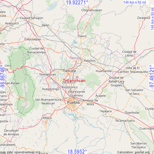
Tetlanohcán GPS coordinates[2]
19° 15' 37.08" North, 98° 9' 51.588" West
| Map corner | latitude | longitude |
|---|---|---|
| Upper-left | 19.92271°, | -98.86746° |
| Center: | 19.2603°, | -98.16433° |
| Lower-right: | 18.5952°, | -97.46121° |
| Map W x H: | 147.6×147.6 km | = 91.7×91.7mi |
| max Lat: | 32.7° ⇑59.6% North |
| Tetlanohcán: | 19.2603° |
| min Lat: | ⇓40.4% South 14.53588° |
| min Long | Tetlanohcán | max Long |
| -117.105° | -98.16433° | -86.73105° |
| W 61.7%⇐ | ⇒38.3% E |
Elevation
Elevation of Tetlanohcán is 2431 m = 7976 ft, and this is 1177.3 m = 3863 ft above average elevation for this country.
| Max E: |
3497 m = 11473 ft | 9.3% |
| Tetlanohcán | 2431 m 7976 ft | |
| Avg. | 1253.7 m = 4113 ft | |
Min E: |
-1 m = -3 ft | 90.7% |
See also: Mexico elevation on elevation.city.
Geographical zone
Tetlanohcán is located in North Torrid zone (between Equator and Tropic of Cancer). Distance of this Northern Tropic circle is 464.4 km =288.6 mi to North.| Distance of | km | miles | from Tetlanohcán |
|---|---|---|---|
| North Pole | 7865.5 | 4887.4 | to North |
| Arctic Circle | 5259.6 | 3268.2 | to North |
| Tropic Cancer | 464.4 | 288.6 | to North |
| Equator | 2141.5 | 1330.7 | to South |


Nearby cities:
15 places around Tetlanohcán: (largest is in red/bold)
• Acuamanala
5.6 km =3.5 mi,  222°
222°
• Acxotla del Monte
1 km =0.6 mi,  201°
201°
• Concepción Chimalpa
6 km =3.7 mi, 215°
• Cuaxinca
1.8 km =1.1 mi,  176°
176°
• Guadalupe Hidalgo
4.5 km =2.8 mi,  212°
212°
• La Magdalena Tlaltelulco
4.2 km =2.6 mi,  306°
306°
• Olextla de Juárez
5.9 km =3.7 mi, 207°
• San Bartolomé Cuahuixmatlac
4.1 km =2.5 mi,  24°
24°
• San Francisco Tetlanohcan
0.1 km =0.1 mi,  99°
99°
• San Pedro Muñoztla
2.4 km =1.5 mi,  353°
353°
• San Pedro Xochiteotla
5.9 km =3.7 mi,  27°
27°
• Santa Ana Chiautempan
5.7 km =3.5 mi,  334°
334°
• Santa Cruz Tetela
5.8 km =3.6 mi, 308°
• Santa Isabel Xiloxoxtla
5.3 km =3.3 mi,  279°
279°
• Teolocholco
3.4 km =2.1 mi,  235°
235°
Sources, notices
• [Note1] Compared only with cities in Mexico existing in our database
• [Src1] Map data: © OpenStreetMap contributors (CC-BY-SA)
• [Src2] Other city data from geonames.org with taken over terms of usage.
• [Src3] Geographical zone / Annual Mean Temperature by Robert A. Rohde @ Wikipedia
