Guadalupe Hidalgo geodata
Guadalupe Hidalgo (Tlaxcala) is a populated place; located in Mexico in America/Mexico_City (GMT-6) time zone. With population of 1,270 people, there are 6821 cities with bigger population in this country. Compared to other cities in Mexico, 60.6% of cities are located further ↑North; 61.4% of cities are located further ←West and 88.2% of cities have lower elevation than Guadalupe Hidalgo. Note1


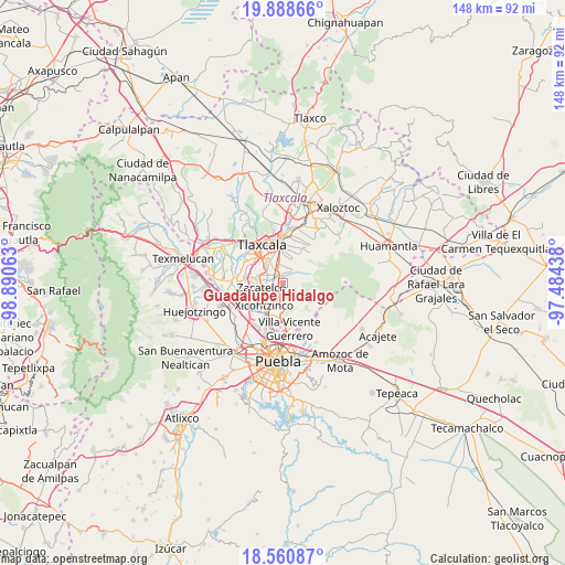
Guadalupe Hidalgo GPS coordinates[2]
19° 13' 33.996" North, 98° 11' 15" West
| Map corner | latitude | longitude |
|---|---|---|
| Upper-left | 19.88866°, | -98.89063° |
| Center: | 19.22611°, | -98.1875° |
| Lower-right: | 18.56087°, | -97.48438° |
| Map W x H: | 147.6×147.6 km | = 91.7×91.7mi |
| max Lat: | 32.7° ⇑60.6% North |
| Guadalupe Hidalgo: | 19.22611° |
| min Lat: | ⇓39.4% South 14.53588° |
| min Long | Guadalupe Hidal | max Long |
| -117.105° | -98.1875° | -86.73105° |
| W 61.4%⇐ | ⇒38.6% E |
Elevation
Elevation of Guadalupe Hidalgo is 2349 m = 7707 ft, and this is 1095.3 m = 3594 ft above average elevation for this country.
| Max E: |
3497 m = 11473 ft | 11.8% |
| Guadalupe Hidalgo | 2349 m 7707 ft | |
| Avg. | 1253.7 m = 4113 ft | |
Min E: |
-1 m = -3 ft | 88.2% |
See also: Mexico elevation on elevation.city.
Geographical zone
Guadalupe Hidalgo is located in North Torrid zone (between Equator and Tropic of Cancer). Distance of this Northern Tropic circle is 468.2 km =290.9 mi to North.| Distance of | km | miles | from Guadalupe Hidalgo |
|---|---|---|---|
| North Pole | 7869.3 | 4889.8 | to North |
| Arctic Circle | 5263.4 | 3270.5 | to North |
| Tropic Cancer | 468.2 | 290.9 | to North |
| Equator | 2137.7 | 1328.3 | to South |


Nearby cities:
15 places around Guadalupe Hidalgo: (largest is in red/bold)
• Acuamanala
1.4 km =0.9 mi,  258°
258°
• Acxotla del Monte
3.6 km =2.2 mi,  35°
35°
• Ayometitla
2.2 km =1.4 mi,  195°
195°
• Concepción Chimalpa
1.5 km =0.9 mi,  225°
225°
• Cuaxinca
3.3 km =2.1 mi,  51°
51°
• El Carmen Aztama
3.4 km =2.1 mi,  276°
276°
• Olextla de Juárez
1.5 km =0.9 mi,  191°
191°
• San Cosme Atlamaxac
4.2 km =2.6 mi,  289°
289°
• San Francisco Tetlanohcan
4.5 km =2.8 mi,  33°
33°
• San Marcos Contla
3.2 km =2 mi, 202°
• San Pedro Xalcaltzinco
4.3 km =2.7 mi,  272°
272°
• Santa Catarina Ayometla
4.1 km =2.5 mi,  221°
221°
• Santa Cruz Quilehtla
3.8 km =2.4 mi,  251°
251°
• Teolocholco
1.9 km =1.2 mi,  349°
349°
• Tetlanohcán
4.5 km =2.8 mi, 32°
Sources, notices
• [Note1] Compared only with cities in Mexico existing in our database
• [Src1] Map data: © OpenStreetMap contributors (CC-BY-SA)
• [Src2] Other city data from geonames.org with taken over terms of usage.
• [Src3] Geographical zone / Annual Mean Temperature by Robert A. Rohde @ Wikipedia
