Rafael Pascacio Gamboa geodata
Rafael Pascacio Gamboa (Chiapas) is a populated place; located in Mexico in America/Mexico_City (GMT-6) time zone. With population of 1,133 people, there are 7654 cities with bigger population in this country. Compared to other cities in Mexico, 79.5% of cities are located further ↑North; 87.3% of cities are located further ←West and 88.3% of cities have higher elevation than Rafael Pascacio Gamboa. Note1
Current local time in Rafael Pascacio Gamboa:
06:48 AM, WednesdayDifference from your time zone: hours


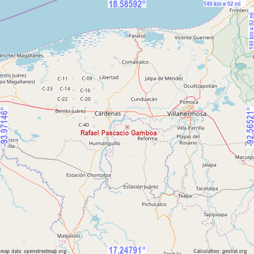
Rafael Pascacio Gamboa GPS coordinates[2]
17° 55' 5.448" North, 93° 16' 5.988" West
| Map corner | latitude | longitude |
|---|---|---|
| Upper-left | 18.58592°, | -93.97146° |
| Center: | 17.91818°, | -93.26833° |
| Lower-right: | 17.24791°, | -92.56521° |
| Map W x H: | 148.8×148.8 km | = 92.5×92.5mi |
| max Lat: | 32.7° ⇑79.5% North |
| Rafael Pascacio Gamboa: | 17.91818° |
| min Lat: | ⇓20.5% South 14.53588° |
| min Long | Rafael Pascacio | max Long |
| -117.105° | -93.26833° | -86.73105° |
| W 87.3%⇐ | ⇒12.7% E |
Elevation
Elevation of Rafael Pascacio Gamboa is 29 m = 95 ft, and this is 1224.7 m = 4018 ft below average elevation for this country.
| Max E: |
3497 m = 11473 ft | 88.3% |
| Avg. | 1253.7 m = 4113 ft | |
| Rafael Pascacio Gamboa | 29 m = 95 ft | |
Min E: |
-1 m = -3 ft | 11.7% |
See also: Mexico elevation on elevation.city.
Geographical zone
Rafael Pascacio Gamboa is located in North Torrid zone (between Equator and Tropic of Cancer). Distance of this Northern Tropic circle is 613.6 km =381.3 mi to North.| Distance of | km | miles | from Rafael Pascacio Gamboa |
|---|---|---|---|
| North Pole | 8014.7 | 4980.1 | to North |
| Arctic Circle | 5408.9 | 3360.9 | to North |
| Tropic Cancer | 613.6 | 381.3 | to North |
| Equator | 1992.3 | 1238 | to South |


Nearby cities:
15 places around Rafael Pascacio Gamboa: (largest is in red/bold)
• Bajío 1ra. Sección A (Perifércio Sur)
11.8 km =7.3 mi,  308°
308°
• Benito Juárez (La Playita)
10.3 km =6.4 mi,  278°
278°
• Carlos Alberto Wilson Gómez
12.6 km =7.8 mi,  328°
328°
• Cucuyulapa Primera Sección
8.2 km =5.1 mi,  9°
9°
• El Carmen (El Limón)
11.3 km =7 mi,  105°
105°
• El Dorado
11.2 km =7 mi,  249°
249°
• El Limoncito
8 km =5 mi,  241°
241°
• Habanero 1ra. Sección (Venustiano Carranza)
8.4 km =5.2 mi, 311°
• La Península
10.2 km =6.3 mi,  285°
285°
• Los Naranjos 1ra. Sección (Campechito)
10.3 km =6.4 mi, 277°
• Los Naranjos 2da. Sección
13 km =8.1 mi, 248°
• Marín
12 km =7.5 mi,  44°
44°
• Marín (Rampa de Panuncio)
10.3 km =6.4 mi, 40°
• San Miguel 2da. Sección
10.2 km =6.3 mi,  97°
97°
• Sección 10 de Azucareros
10.8 km =6.7 mi, 291°
Sources, notices
• [Note1] Compared only with cities in Mexico existing in our database
• [Src1] Map data: © OpenStreetMap contributors (CC-BY-SA)
• [Src2] Other city data from geonames.org with taken over terms of usage.
• [Src3] Geographical zone / Annual Mean Temperature by Robert A. Rohde @ Wikipedia
