El Limoncito geodata
El Limoncito (Chiapas) is a populated place; located in Mexico in America/Mexico_City (GMT-6) time zone. With population of 667 people, there are 13011 cities with bigger population in this country. Compared to other cities in Mexico, 79.9% of cities are located further ↑North; 87.1% of cities are located further ←West and 85.7% of cities have higher elevation than El Limoncito. Note1


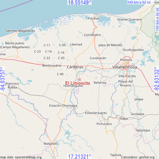
El Limoncito GPS coordinates[2]
17° 53' 0.996" North, 93° 20' 3.984" West
| Map corner | latitude | longitude |
|---|---|---|
| Upper-left | 18.55149°, | -94.03757° |
| Center: | 17.88361°, | -93.33444° |
| Lower-right: | 17.21321°, | -92.63132° |
| Map W x H: | 148.8×148.8 km | = 92.5×92.5mi |
| max Lat: | 32.7° ⇑79.9% North |
| El Limoncito: | 17.88361° |
| min Lat: | ⇓20.1% South 14.53588° |
| min Long | El Limoncito | max Long |
| -117.105° | -93.33444° | -86.73105° |
| W 87.1%⇐ | ⇒12.9% E |
Elevation
Elevation of El Limoncito is 40 m = 131 ft, and this is 1213.7 m = 3982 ft below average elevation for this country.
| Max E: |
3497 m = 11473 ft | 85.7% |
| Avg. | 1253.7 m = 4113 ft | |
| El Limoncito | 40 m = 131 ft | |
Min E: |
-1 m = -3 ft | 14.3% |
See also: Mexico elevation on elevation.city.
Geographical zone
El Limoncito is located in North Torrid zone (between Equator and Tropic of Cancer). Distance of this Northern Tropic circle is 617.4 km =383.6 mi to North.| Distance of | km | miles | from El Limoncito |
|---|---|---|---|
| North Pole | 8018.6 | 4982.5 | to North |
| Arctic Circle | 5412.7 | 3363.3 | to North |
| Tropic Cancer | 617.4 | 383.6 | to North |
| Equator | 1988.5 | 1235.6 | to South |


Nearby cities:
15 places around El Limoncito: (largest is in red/bold)
• Arroyo Hondo Abejonal
13.2 km =8.2 mi,  322°
322°
• Bajío 1ra. Sección A (Perifércio Sur)
11.4 km =7.1 mi,  348°
348°
• Benito Juárez (La Playita)
6.3 km =3.9 mi,  329°
329°
• C-41 (Licenciado Carlos A. Madrazo)
12.8 km =8 mi,  290°
290°
• Cárdenas
13.8 km =8.6 mi,  341°
341°
• El Dorado
3.5 km =2.2 mi,  269°
269°
• Habanero 1ra. Sección (Venustiano Carranza)
9.4 km =5.8 mi,  4°
4°
• Huimanguillo
8 km =5 mi,  226°
226°
• La Luz
10.4 km =6.5 mi, 226°
• La Península
7.2 km =4.5 mi, 336°
• Libertad
10.5 km =6.5 mi,  237°
237°
• Los Naranjos 1ra. Sección (Campechito)
6.1 km =3.8 mi, 327°
• Los Naranjos 2da. Sección
5.2 km =3.2 mi,  260°
260°
• Rafael Pascacio Gamboa
8 km =5 mi,  61°
61°
• Sección 10 de Azucareros
8.4 km =5.2 mi, 339°
Sources, notices
• [Note1] Compared only with cities in Mexico existing in our database
• [Src1] Map data: © OpenStreetMap contributors (CC-BY-SA)
• [Src2] Other city data from geonames.org with taken over terms of usage.
• [Src3] Geographical zone / Annual Mean Temperature by Robert A. Rohde @ Wikipedia
