El Progreso geodata
El Progreso (Chiapas) is a populated place; located in Mexico in America/Mexico_City (GMT-6) time zone. With population of 924 people, there are 9451 cities with bigger population in this country. Compared to other cities in Mexico, 84.1% of cities are located further ↑North; 92.9% of cities are located further ←West and 82.1% of cities have higher elevation than El Progreso. Note1


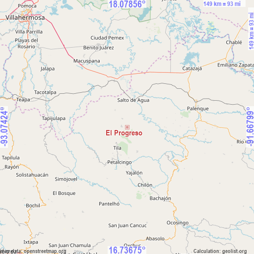
El Progreso GPS coordinates[2]
17° 24' 32.004" North, 92° 22' 15.996" West
| Map corner | latitude | longitude |
|---|---|---|
| Upper-left | 18.07856°, | -93.07424° |
| Center: | 17.40889°, | -92.37111° |
| Lower-right: | 16.73675°, | -91.66799° |
| Map W x H: | 149.2×149.2 km | = 92.7×92.7mi |
| max Lat: | 32.7° ⇑84.1% North |
| El Progreso: | 17.40889° |
| min Lat: | ⇓15.9% South 14.53588° |
| min Long | El Progreso | max Long |
| -117.105° | -92.37111° | -86.73105° |
| W 92.9%⇐ | ⇒7.1% E |
Elevation
Elevation of El Progreso is 69 m = 226 ft, and this is 1184.7 m = 3887 ft below average elevation for this country.
| Max E: |
3497 m = 11473 ft | 82.1% |
| Avg. | 1253.7 m = 4113 ft | |
| El Progreso | 69 m = 226 ft | |
Min E: |
-1 m = -3 ft | 17.9% |
See also: Mexico elevation on elevation.city.
Geographical zone
El Progreso is located in North Torrid zone (between Equator and Tropic of Cancer). Distance of this Northern Tropic circle is 670.2 km =416.4 mi to North.| Distance of | km | miles | from El Progreso |
|---|---|---|---|
| North Pole | 8071.4 | 5015.3 | to North |
| Arctic Circle | 5465.5 | 3396.1 | to North |
| Tropic Cancer | 670.2 | 416.4 | to North |
| Equator | 1935.7 | 1202.8 | to South |


Nearby cities:
15 places around El Progreso: (largest is in red/bold)
• Campanario
6.8 km =4.2 mi,  18°
18°
• Cenobio Aguilar (La Trinidad)
5.5 km =3.4 mi,  94°
94°
• Chuchuclumil
9.8 km =6.1 mi,  99°
99°
• El Carrizal
8.4 km =5.2 mi,  217°
217°
• El Crucero
10.7 km =6.6 mi,  245°
245°
• El Limar
3.4 km =2.1 mi,  281°
281°
• Emiliano Zapata
11.7 km =7.3 mi,  132°
132°
• Jochinteol
11.2 km =7 mi,  345°
345°
• Joloniel
7.9 km =4.9 mi, 134°
• La Esperanza del Porvenir
6 km =3.7 mi,  148°
148°
• Mariscal Subikuski
8.6 km =5.3 mi,  186°
186°
• Mariscal Yehuitz
6.7 km =4.2 mi,  173°
173°
• Nuevo Limar
5.9 km =3.7 mi,  330°
330°
• Tza'Quil
11 km =6.8 mi,  265°
265°
• Usipa
12.4 km =7.7 mi, 325°
Sources, notices
• [Note1] Compared only with cities in Mexico existing in our database
• [Src1] Map data: © OpenStreetMap contributors (CC-BY-SA)
• [Src2] Other city data from geonames.org with taken over terms of usage.
• [Src3] Geographical zone / Annual Mean Temperature by Robert A. Rohde @ Wikipedia
