La Ceiba geodata
La Ceiba (Chiapas) is a populated place; located in Mexico in America/Mexico_City (GMT-6) time zone. With population of 1,275 people, there are 6794 cities with bigger population in this country. Compared to other cities in Mexico, 87.3% of cities are located further ↑North; 91.7% of cities are located further ←West and 67% of cities have higher elevation than La Ceiba. Note1


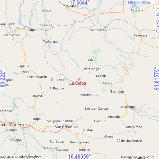
La Ceiba GPS coordinates[2]
17° 8' 1.356" North, 92° 31' 7.932" West
| Map corner | latitude | longitude |
|---|---|---|
| Upper-left | 17.8044°, | -93.222° |
| Center: | 17.13371°, | -92.51887° |
| Lower-right: | 16.46059°, | -91.81575° |
| Map W x H: | 149.4×149.4 km | = 92.8×92.8mi |
| max Lat: | 32.7° ⇑87.3% North |
| La Ceiba: | 17.13371° |
| min Lat: | ⇓12.7% South 14.53588° |
| min Long | La Ceiba | max Long |
| -117.105° | -92.51887° | -86.73105° |
| W 91.7%⇐ | ⇒8.3% E |
Elevation
Elevation of La Ceiba is 586 m = 1923 ft, and this is 667.7 m = 2191 ft below average elevation for this country.
| Max E: |
3497 m = 11473 ft | 67% |
| Avg. | 1253.7 m = 4113 ft | |
| La Ceiba | 586 m = 1923 ft | |
Min E: |
-1 m = -3 ft | 33% |
See also: Mexico elevation on elevation.city.
Geographical zone
La Ceiba is located in North Torrid zone (between Equator and Tropic of Cancer). Distance of this Northern Tropic circle is 700.8 km =435.5 mi to North.| Distance of | km | miles | from La Ceiba |
|---|---|---|---|
| North Pole | 8102 | 5034.3 | to North |
| Arctic Circle | 5496.1 | 3415.1 | to North |
| Tropic Cancer | 700.8 | 435.5 | to North |
| Equator | 1905.1 | 1183.8 | to South |


Nearby cities:
15 places around La Ceiba: (largest is in red/bold)
• Aurora Esquipulas
4.9 km =3 mi,  112°
112°
• Buenavista
10.2 km =6.3 mi,  355°
355°
• Constitución
6.5 km =4 mi,  184°
184°
• Cruztón
8.7 km =5.4 mi,  186°
186°
• El Calvario
10.2 km =6.3 mi,  336°
336°
• El Jardín
9.3 km =5.8 mi,  293°
293°
• El Roblar Chishtontic
7.9 km =4.9 mi,  165°
165°
• Joljá
8.1 km =5 mi,  14°
14°
• José Castillo Tielemans
1.7 km =1.1 mi,  318°
318°
• Las Mercedes Esperanza
4.5 km =2.8 mi,  239°
239°
• Maravillas
4.1 km =2.5 mi,  274°
274°
• Nuevo Sitalá
3.9 km =2.4 mi,  80°
80°
• San Antonio Nuevo León
4.5 km =2.8 mi,  308°
308°
• Shoctic
10.5 km =6.5 mi,  18°
18°
• Vinoté
1.8 km =1.1 mi,  29°
29°
Sources, notices
• [Note1] Compared only with cities in Mexico existing in our database
• [Src1] Map data: © OpenStreetMap contributors (CC-BY-SA)
• [Src2] Other city data from geonames.org with taken over terms of usage.
• [Src3] Geographical zone / Annual Mean Temperature by Robert A. Rohde @ Wikipedia
