Monterrey geodata
Monterrey (Chiapas) is a populated place; located in Mexico in America/Mexico_City (GMT-6) time zone. With population of 578 people, there are 14828 cities with bigger population in this country. Compared to other cities in Mexico, 90.1% of cities are located further ↑North; 87.4% of cities are located further ←West and 63.2% of cities have higher elevation than Monterrey. Note1


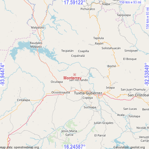
Monterrey GPS coordinates[2]
16° 55' 11.1" North, 93° 14' 29.796" West
| Map corner | latitude | longitude |
|---|---|---|
| Upper-left | 17.59122°, | -93.94474° |
| Center: | 16.91975°, | -93.24161° |
| Lower-right: | 16.24587°, | -92.53849° |
| Map W x H: | 149.6×149.6 km | = 93×93mi |
| max Lat: | 32.7° ⇑90.1% North |
| Monterrey: | 16.91975° |
| min Lat: | ⇓9.9% South 14.53588° |
| min Long | Monterrey | max Long |
| -117.105° | -93.24161° | -86.73105° |
| W 87.4%⇐ | ⇒12.6% E |
Elevation
Elevation of Monterrey is 803 m = 2635 ft, and this is 450.7 m = 1479 ft below average elevation for this country.
| Max E: |
3497 m = 11473 ft | 63.2% |
| Avg. | 1253.7 m = 4113 ft | |
| Monterrey | 803 m = 2635 ft | |
Min E: |
-1 m = -3 ft | 36.8% |
See also: Mexico elevation on elevation.city.
Geographical zone
Monterrey is located in North Torrid zone (between Equator and Tropic of Cancer). Distance of this Northern Tropic circle is 724.6 km =450.2 mi to North.| Distance of | km | miles | from Monterrey |
|---|---|---|---|
| North Pole | 8125.8 | 5049.1 | to North |
| Arctic Circle | 5519.9 | 3429.9 | to North |
| Tropic Cancer | 724.6 | 450.2 | to North |
| Equator | 1881.3 | 1169 | to South |


Nearby cities:
15 places around Monterrey: (largest is in red/bold)
• Benito Juárez
6.9 km =4.3 mi,  125°
125°
• Cuauhtémoc
2.5 km =1.6 mi,  61°
61°
• Efraín A. Gutiérrez
7.2 km =4.5 mi,  234°
234°
• El Carmelo
12.9 km =8 mi,  83°
83°
• El Copalar
5.6 km =3.5 mi,  148°
148°
• El Portillo
6 km =3.7 mi,  159°
159°
• El Progreso
5.2 km =3.2 mi, 156°
• Francisco I. Madero
5.7 km =3.5 mi, 152°
• Gabriel Esquinca
7.4 km =4.6 mi,  71°
71°
• Las Maravillas
9.4 km =5.8 mi,  297°
297°
• Miguel Hidalgo
6 km =3.7 mi,  175°
175°
• San Fernando
6.5 km =4 mi, 145°
• Vicente Guerrero
7.9 km =4.9 mi, 161°
• Viva Cárdenas
10.7 km =6.6 mi, 151°
• Álvaro Obregón
9.9 km =6.2 mi, 148°
Sources, notices
• [Note1] Compared only with cities in Mexico existing in our database
• [Src1] Map data: © OpenStreetMap contributors (CC-BY-SA)
• [Src2] Other city data from geonames.org with taken over terms of usage.
• [Src3] Geographical zone / Annual Mean Temperature by Robert A. Rohde @ Wikipedia
