Adolfo López Mateos geodata
Adolfo López Mateos (Chiapas) is a populated place; located in Mexico in America/Mexico_City (GMT-6) time zone. With population of 507 people, there are 16589 cities with bigger population in this country. Compared to other cities in Mexico, 93.5% of cities are located further ↑North; 89.2% of cities are located further ←West and 69.8% of cities have higher elevation than Adolfo López Mateos. Note1


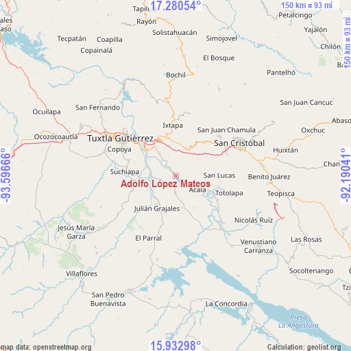
Adolfo López Mateos GPS coordinates[2]
16° 36' 28.584" North, 92° 53' 36.708" West
| Map corner | latitude | longitude |
|---|---|---|
| Upper-left | 17.28054°, | -93.59666° |
| Center: | 16.60794°, | -92.89353° |
| Lower-right: | 15.93298°, | -92.19041° |
| Map W x H: | 149.8×149.8 km | = 93.1×93.1mi |
| max Lat: | 32.7° ⇑93.5% North |
| Adolfo López Mateos: | 16.60794° |
| min Lat: | ⇓6.5% South 14.53588° |
| min Long | Adolfo López M | max Long |
| -117.105° | -92.89353° | -86.73105° |
| W 89.2%⇐ | ⇒10.8% E |
Elevation
Elevation of Adolfo López Mateos is 425 m = 1394 ft, and this is 828.7 m = 2719 ft below average elevation for this country.
| Max E: |
3497 m = 11473 ft | 69.8% |
| Avg. | 1253.7 m = 4113 ft | |
| Adolfo López Mateos | 425 m = 1394 ft | |
Min E: |
-1 m = -3 ft | 30.2% |
See also: Mexico elevation on elevation.city.
Geographical zone
Adolfo López Mateos is located in North Torrid zone (between Equator and Tropic of Cancer). Distance of this Northern Tropic circle is 759.3 km =471.8 mi to North.| Distance of | km | miles | from Adolfo López Mateos |
|---|---|---|---|
| North Pole | 8160.4 | 5070.6 | to North |
| Arctic Circle | 5554.5 | 3451.4 | to North |
| Tropic Cancer | 759.3 | 471.8 | to North |
| Equator | 1846.6 | 1147.4 | to South |


Nearby cities:
15 places around Adolfo López Mateos: (largest is in red/bold)
• Acala
11.1 km =6.9 mi,  121°
121°
• Amatal
11.4 km =7.1 mi,  286°
286°
• América Libre
10.5 km =6.5 mi,  274°
274°
• Chiquinivalvo
12 km =7.5 mi,  21°
21°
• Francisco Sarabia
13.2 km =8.2 mi,  244°
244°
• General Emiliano Zapata Dos
8.6 km =5.3 mi,  316°
316°
• Jobchenón (La Granadilla)
12.6 km =7.8 mi,  28°
28°
• Multajo
12.8 km =8 mi,  9°
9°
• Narciso Mendoza
10.6 km =6.6 mi,  253°
253°
• Nucatilí
9.1 km =5.7 mi,  340°
340°
• Nueva Palestina (Nandayacuti)
10.4 km =6.5 mi,  305°
305°
• Nuevo Carmen Tonapac
11.9 km =7.4 mi,  326°
326°
• Ribera de Monte Rico (Nacamucuyi)
13.1 km =8.1 mi, 307°
• Ribera la Unión (Castaño)
10.8 km =6.7 mi, 266°
• Salvador Urbina
12 km =7.5 mi,  284°
284°
Sources, notices
• [Note1] Compared only with cities in Mexico existing in our database
• [Src1] Map data: © OpenStreetMap contributors (CC-BY-SA)
• [Src2] Other city data from geonames.org with taken over terms of usage.
• [Src3] Geographical zone / Annual Mean Temperature by Robert A. Rohde @ Wikipedia
