Acala geodata
Acala (Chiapas) is a seat of a second-order administrative division; located in Mexico in America/Mexico_City (GMT-6) time zone. With population of 13,889 people, there are 699 cities with bigger population in this country. Compared to other cities in Mexico, 94% of cities are located further ↑North; 89.8% of cities are located further ←West and 69.9% of cities have higher elevation than Acala. Note1


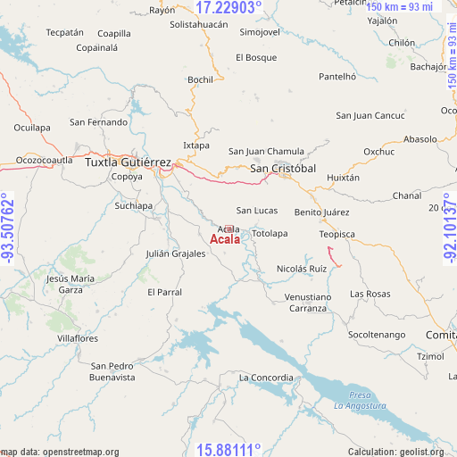
Acala GPS coordinates[2]
16° 33' 22.5" North, 92° 48' 16.164" West
| Map corner | latitude | longitude |
|---|---|---|
| Upper-left | 17.22903°, | -93.50762° |
| Center: | 16.55625°, | -92.80449° |
| Lower-right: | 15.88111°, | -92.10137° |
| Map W x H: | 149.9×149.9 km | = 93.1×93.1mi |
| max Lat: | 32.7° ⇑94% North |
| Acala: | 16.55625° |
| min Lat: | ⇓6% South 14.53588° |
| min Long | Acala | max Long |
| -117.105° | -92.80449° | -86.73105° |
| W 89.8%⇐ | ⇒10.2% E |
Elevation
Elevation of Acala is 420 m = 1378 ft, and this is 833.7 m = 2735 ft below average elevation for this country.
| Max E: |
3497 m = 11473 ft | 69.9% |
| Avg. | 1253.7 m = 4113 ft | |
| Acala | 420 m = 1378 ft | |
Min E: |
-1 m = -3 ft | 30.1% |
See also: Mexico elevation on elevation.city.
Geographical zone
Acala is located in North Torrid zone (between Equator and Tropic of Cancer). Distance of this Northern Tropic circle is 765 km =475.3 mi to North.| Distance of | km | miles | from Acala |
|---|---|---|---|
| North Pole | 8166.2 | 5074.2 | to North |
| Arctic Circle | 5560.3 | 3455 | to North |
| Tropic Cancer | 765 | 475.3 | to North |
| Equator | 1840.9 | 1143.9 | to South |


Nearby cities:
15 places around Acala: (largest is in red/bold)
• Adolfo López Mateos
11.1 km =6.9 mi,  301°
301°
• Apas
17.2 km =10.7 mi,  3°
3°
• Belisario Domínguez
17.3 km =10.7 mi,  165°
165°
• Chiapilla
9.1 km =5.7 mi,  80°
80°
• Francisco Villa
14.1 km =8.8 mi,  73°
73°
• Jobchenón (La Granadilla)
17.2 km =10.7 mi,  348°
348°
• Laguna del Carmen
14.6 km =9.1 mi,  45°
45°
• Luis Echeverría Álvarez
15.2 km =9.4 mi,  175°
175°
• Lázaro Cárdenas
4.4 km =2.7 mi,  94°
94°
• Nuevo Vicente Guerrero (El Chichonal)
10.6 km =6.6 mi,  222°
222°
• San José Buenavista
10.7 km =6.6 mi, 46°
• San Lucas
11.1 km =6.9 mi,  56°
56°
• Totolapa
13.3 km =8.3 mi,  96°
96°
• Unión Buena Vista
8 km =5 mi,  190°
190°
• Vicente Guerrero
16.3 km =10.1 mi,  143°
143°
Sources, notices
• [Note1] Compared only with cities in Mexico existing in our database
• [Src1] Map data: © OpenStreetMap contributors (CC-BY-SA)
• [Src2] Other city data from geonames.org with taken over terms of usage.
• [Src3] Geographical zone / Annual Mean Temperature by Robert A. Rohde @ Wikipedia
