Lázaro Cárdenas geodata
Lázaro Cárdenas (Chiapas) is a populated place; located in Mexico in America/Mexico_City (GMT-6) time zone. With population of 1,172 people, there are 7412 cities with bigger population in this country. Compared to other cities in Mexico, 95.8% of cities are located further ↑North; 85.8% of cities are located further ←West and 81.4% of cities have higher elevation than Lázaro Cárdenas. Note1


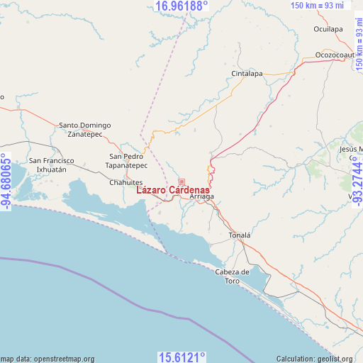
Lázaro Cárdenas GPS coordinates[2]
16° 17' 17.34" North, 93° 58' 39.072" West
| Map corner | latitude | longitude |
|---|---|---|
| Upper-left | 16.96188°, | -94.68065° |
| Center: | 16.28815°, | -93.97752° |
| Lower-right: | 15.6121°, | -93.2744° |
| Map W x H: | 150.1×150.1 km | = 93.3×93.3mi |
| max Lat: | 32.7° ⇑95.8% North |
| Lázaro Cárdenas: | 16.28815° |
| min Lat: | ⇓4.2% South 14.53588° |
| min Long | Lázaro Cárden | max Long |
| -117.105° | -93.97752° | -86.73105° |
| W 85.8%⇐ | ⇒14.2% E |
Elevation
Elevation of Lázaro Cárdenas is 77 m = 253 ft, and this is 1176.7 m = 3861 ft below average elevation for this country.
| Max E: |
3497 m = 11473 ft | 81.4% |
| Avg. | 1253.7 m = 4113 ft | |
| Lázaro Cárdenas | 77 m = 253 ft | |
Min E: |
-1 m = -3 ft | 18.6% |
See also: Mexico elevation on elevation.city.
Geographical zone
Lázaro Cárdenas is located in North Torrid zone (between Equator and Tropic of Cancer). Distance of this Northern Tropic circle is 794.8 km =493.9 mi to North.| Distance of | km | miles | from Lázaro Cárdenas |
|---|---|---|---|
| North Pole | 8196 | 5092.8 | to North |
| Arctic Circle | 5590.1 | 3473.5 | to North |
| Tropic Cancer | 794.8 | 493.9 | to North |
| Equator | 1811.1 | 1125.4 | to South |


Nearby cities:
15 places around Lázaro Cárdenas: (largest is in red/bold)
• Arriaga
10.1 km =6.3 mi,  125°
125°
• Azteca
8.5 km =5.3 mi,  156°
156°
• Chahuite
22 km =13.7 mi,  273°
273°
• Durango
20.2 km =12.6 mi,  146°
146°
• El Espinal
16.2 km =10.1 mi,  303°
303°
• Emiliano Zapata
15.8 km =9.8 mi,  216°
216°
• La Gloria
20.9 km =13 mi, 219°
• La Línea
18.6 km =11.6 mi,  199°
199°
• Los Corazones
13.4 km =8.3 mi,  229°
229°
• Nicolás Bravo
7 km =4.3 mi,  108°
108°
• Punta Flor
20.6 km =12.8 mi,  180°
180°
• Rosendo Salazar
20.2 km =12.6 mi,  352°
352°
• Tierra y Libertad
16 km =9.9 mi,  51°
51°
• Tiltepec
16.4 km =10.2 mi,  44°
44°
• Villamorelos
22 km =13.7 mi,  13°
13°
Sources, notices
• [Note1] Compared only with cities in Mexico existing in our database
• [Src1] Map data: © OpenStreetMap contributors (CC-BY-SA)
• [Src2] Other city data from geonames.org with taken over terms of usage.
• [Src3] Geographical zone / Annual Mean Temperature by Robert A. Rohde @ Wikipedia
