Villamorelos geodata
Villamorelos (Chiapas) is a populated place; located in Mexico in America/Mexico_City (GMT-6) time zone. With population of 1,677 people, there are 5173 cities with bigger population in this country. Compared to other cities in Mexico, 94.5% of cities are located further ↑North; 85.9% of cities are located further ←West and 64.7% of cities have higher elevation than Villamorelos. Note1


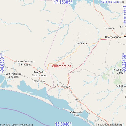
Villamorelos GPS coordinates[2]
16° 28' 48" North, 93° 55' 40.008" West
| Map corner | latitude | longitude |
|---|---|---|
| Upper-left | 17.15305°, | -94.63091° |
| Center: | 16.48°, | -93.92778° |
| Lower-right: | 15.8046°, | -93.22466° |
| Map W x H: | 149.9×149.9 km | = 93.1×93.1mi |
| max Lat: | 32.7° ⇑94.5% North |
| Villamorelos: | 16.48° |
| min Lat: | ⇓5.5% South 14.53588° |
| min Long | Villamorelos | max Long |
| -117.105° | -93.92778° | -86.73105° |
| W 85.9%⇐ | ⇒14.1% E |
Elevation
Elevation of Villamorelos is 707 m = 2320 ft, and this is 546.7 m = 1794 ft below average elevation for this country.
| Max E: |
3497 m = 11473 ft | 64.7% |
| Avg. | 1253.7 m = 4113 ft | |
| Villamorelos | 707 m = 2320 ft | |
Min E: |
-1 m = -3 ft | 35.3% |
See also: Mexico elevation on elevation.city.
Geographical zone
Villamorelos is located in North Torrid zone (between Equator and Tropic of Cancer). Distance of this Northern Tropic circle is 773.5 km =480.6 mi to North.| Distance of | km | miles | from Villamorelos |
|---|---|---|---|
| North Pole | 8174.7 | 5079.5 | to North |
| Arctic Circle | 5568.8 | 3460.3 | to North |
| Tropic Cancer | 773.5 | 480.6 | to North |
| Equator | 1832.4 | 1138.6 | to South |


Nearby cities:
15 places around Villamorelos: (largest is in red/bold)
• Baja California
15.1 km =9.4 mi,  110°
110°
• Cereso 14 (El Amate)
18.4 km =11.4 mi,  46°
46°
• Chiapas Nuevo
11.1 km =6.9 mi,  104°
104°
• El Espinal
22.6 km =14 mi,  236°
236°
• El Triunfo
18.9 km =11.7 mi, 95°
• José María Pino Suárez
20.3 km =12.6 mi,  81°
81°
• Lázaro Cárdenas
20 km =12.4 mi, 46°
• Lázaro Cárdenas
22 km =13.7 mi,  193°
193°
• Mérida
15.3 km =9.5 mi, 50°
• Nueva Tenochtitlán (Rizo de Oro)
16.3 km =10.1 mi,  268°
268°
• Pomposo Castellanos
13.9 km =8.6 mi,  27°
27°
• Rosendo Salazar
8 km =5 mi,  260°
260°
• Tehuacán
13.3 km =8.3 mi,  343°
343°
• Tierra y Libertad
13.3 km =8.3 mi,  147°
147°
• Tiltepec
11.4 km =7.1 mi, 147°
Sources, notices
• [Note1] Compared only with cities in Mexico existing in our database
• [Src1] Map data: © OpenStreetMap contributors (CC-BY-SA)
• [Src2] Other city data from geonames.org with taken over terms of usage.
• [Src3] Geographical zone / Annual Mean Temperature by Robert A. Rohde @ Wikipedia
