Azteca geodata
Azteca (Chiapas) is a populated place; located in Mexico in America/Mexico_City (GMT-6) time zone. With population of 1,829 people, there are 4753 cities with bigger population in this country. Compared to other cities in Mexico, 96.2% of cities are located further ↑North; 85.9% of cities are located further ←West and 86.3% of cities have higher elevation than Azteca. Note1


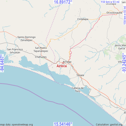
Azteca GPS coordinates[2]
16° 13' 3.9" North, 93° 56' 44.052" West
| Map corner | latitude | longitude |
|---|---|---|
| Upper-left | 16.89172°, | -94.6487° |
| Center: | 16.21775°, | -93.94557° |
| Lower-right: | 15.54146°, | -93.24245° |
| Map W x H: | 150.1×150.1 km | = 93.3×93.3mi |
| max Lat: | 32.7° ⇑96.2% North |
| Azteca: | 16.21775° |
| min Lat: | ⇓3.8% South 14.53588° |
| min Long | Azteca | max Long |
| -117.105° | -93.94557° | -86.73105° |
| W 85.9%⇐ | ⇒14.1% E |
Elevation
Elevation of Azteca is 37 m = 121 ft, and this is 1216.7 m = 3992 ft below average elevation for this country.
| Max E: |
3497 m = 11473 ft | 86.3% |
| Avg. | 1253.7 m = 4113 ft | |
| Azteca | 37 m = 121 ft | |
Min E: |
-1 m = -3 ft | 13.7% |
See also: Mexico elevation on elevation.city.
Geographical zone
Azteca is located in North Torrid zone (between Equator and Tropic of Cancer). Distance of this Northern Tropic circle is 802.7 km =498.8 mi to North.| Distance of | km | miles | from Azteca |
|---|---|---|---|
| North Pole | 8203.8 | 5097.6 | to North |
| Arctic Circle | 5597.9 | 3478.4 | to North |
| Tropic Cancer | 802.7 | 498.8 | to North |
| Equator | 1803.2 | 1120.5 | to South |


Nearby cities:
15 places around Azteca: (largest is in red/bold)
• Arriaga
5.3 km =3.3 mi,  67°
67°
• Democrática Chiapaneca
22.9 km =14.2 mi,  129°
129°
• Durango
11.9 km =7.4 mi,  139°
139°
• Emiliano Zapata
13.7 km =8.5 mi,  248°
248°
• Huanacastal
14.5 km =9 mi,  124°
124°
• Ignacio Ramírez
14.2 km =8.8 mi,  146°
146°
• La Gloria
18.7 km =11.6 mi,  243°
243°
• La Línea
13.6 km =8.5 mi,  224°
224°
• Los Corazones
13.7 km =8.5 mi,  266°
266°
• Lázaro Cárdenas
8.5 km =5.3 mi,  336°
336°
• Nicolás Bravo
6.4 km =4 mi,  30°
30°
• Paredón
20.4 km =12.7 mi,  155°
155°
• Punta Flor
13.2 km =8.2 mi,  195°
195°
• Tierra y Libertad
20.1 km =12.5 mi, 26°
• Tiltepec
21.2 km =13.2 mi,  22°
22°
Sources, notices
• [Note1] Compared only with cities in Mexico existing in our database
• [Src1] Map data: © OpenStreetMap contributors (CC-BY-SA)
• [Src2] Other city data from geonames.org with taken over terms of usage.
• [Src3] Geographical zone / Annual Mean Temperature by Robert A. Rohde @ Wikipedia
