Paredón geodata
Paredón (Chiapas) is a populated place; located in Mexico in America/Mexico_City (GMT-6) time zone. With population of 6,126 people, there are 1527 cities with bigger population in this country. Compared to other cities in Mexico, 97.1% of cities are located further ↑North; 85.9% of cities are located further ←West and 98.7% of cities have higher elevation than Paredón. Note1


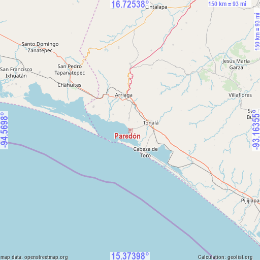
Paredón GPS coordinates[2]
16° 3' 2.988" North, 93° 52' 0.012" West
| Map corner | latitude | longitude |
|---|---|---|
| Upper-left | 16.72538°, | -94.5698° |
| Center: | 16.05083°, | -93.86667° |
| Lower-right: | 15.37398°, | -93.16355° |
| Map W x H: | 150.3×150.3 km | = 93.4×93.4mi |
| max Lat: | 32.7° ⇑97.1% North |
| Paredón: | 16.05083° |
| min Lat: | ⇓2.9% South 14.53588° |
| min Long | Paredón | max Long |
| -117.105° | -93.86667° | -86.73105° |
| W 85.9%⇐ | ⇒14.1% E |
Elevation
Elevation of Paredón is 7 m = 23 ft, and this is 1246.7 m = 4090 ft below average elevation for this country.
| Max E: |
3497 m = 11473 ft | 98.7% |
| Avg. | 1253.7 m = 4113 ft | |
| Paredón | 7 m = 23 ft | |
Min E: |
-1 m = -3 ft | 1.3% |
See also: Mexico elevation on elevation.city.
Geographical zone
Paredón is located in North Torrid zone (between Equator and Tropic of Cancer). Distance of this Northern Tropic circle is 821.2 km =510.3 mi to North.| Distance of | km | miles | from Paredón |
|---|---|---|---|
| North Pole | 8222.4 | 5109.2 | to North |
| Arctic Circle | 5616.5 | 3489.9 | to North |
| Tropic Cancer | 821.2 | 510.3 | to North |
| Equator | 1784.7 | 1109 | to South |


Nearby cities:
15 places around Paredón: (largest is in red/bold)
• Democrática Chiapaneca
10.1 km =6.3 mi,  66°
66°
• Durango
9.6 km =6 mi,  355°
355°
• El Congreso
8.2 km =5.1 mi,  90°
90°
• Huanacastal
11 km =6.8 mi,  18°
18°
• Huizachal
7.1 km =4.4 mi, 89°
• Ignacio Ramírez
6.7 km =4.2 mi,  354°
354°
• La Laguna
8.4 km =5.2 mi,  129°
129°
• Llano Largo
8.2 km =5.1 mi,  113°
113°
• Miguel Hidalgo Número Dos (Veinte de Noviembre)
12.6 km =7.8 mi,  151°
151°
• Noyola
10.7 km =6.6 mi,  97°
97°
• Punta Flor
13.3 km =8.3 mi,  296°
296°
• San Luqueño
4.8 km =3 mi, 152°
• San Nicolás
6.3 km =3.9 mi,  81°
81°
• Tonalá
12.7 km =7.9 mi, 70°
• Villahermosa
6.3 km =3.9 mi, 126°
Sources, notices
• [Note1] Compared only with cities in Mexico existing in our database
• [Src1] Map data: © OpenStreetMap contributors (CC-BY-SA)
• [Src2] Other city data from geonames.org with taken over terms of usage.
• [Src3] Geographical zone / Annual Mean Temperature by Robert A. Rohde @ Wikipedia
