San Nicolás geodata
San Nicolás (Chiapas) is a populated place; located in Mexico in America/Mexico_City (GMT-6) time zone. With population of 628 people, there are 13781 cities with bigger population in this country. Compared to other cities in Mexico, 97.1% of cities are located further ↑North; 86% of cities are located further ←West and 90.8% of cities have higher elevation than San Nicolás. Note1


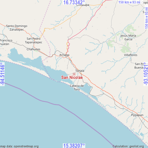
San Nicolás GPS coordinates[2]
16° 3' 32.004" North, 93° 48' 29.988" West
| Map corner | latitude | longitude |
|---|---|---|
| Upper-left | 16.73342°, | -94.51146° |
| Center: | 16.05889°, | -93.80833° |
| Lower-right: | 15.38207°, | -93.10521° |
| Map W x H: | 150.3×150.3 km | = 93.4×93.4mi |
| max Lat: | 32.7° ⇑97.1% North |
| San Nicolás: | 16.05889° |
| min Lat: | ⇓2.9% South 14.53588° |
| min Long | San Nicolás | max Long |
| -117.105° | -93.80833° | -86.73105° |
| W 86%⇐ | ⇒14% E |
Elevation
Elevation of San Nicolás is 22 m = 72 ft, and this is 1231.7 m = 4041 ft below average elevation for this country.
| Max E: |
3497 m = 11473 ft | 90.8% |
| Avg. | 1253.7 m = 4113 ft | |
| San Nicolás | 22 m = 72 ft | |
Min E: |
-1 m = -3 ft | 9.2% |
See also: Mexico elevation on elevation.city.
Geographical zone
San Nicolás is located in North Torrid zone (between Equator and Tropic of Cancer). Distance of this Northern Tropic circle is 820.3 km =509.7 mi to North.| Distance of | km | miles | from San Nicolás |
|---|---|---|---|
| North Pole | 8221.5 | 5108.6 | to North |
| Arctic Circle | 5615.6 | 3489.4 | to North |
| Tropic Cancer | 820.3 | 509.7 | to North |
| Equator | 1785.6 | 1109.5 | to South |


Nearby cities:
15 places around San Nicolás: (largest is in red/bold)
• Democrática Chiapaneca
4.4 km =2.7 mi,  43°
43°
• Durango
11.1 km =6.9 mi,  321°
321°
• El Congreso
2.2 km =1.4 mi,  117°
117°
• Huanacastal
9.9 km =6.2 mi,  344°
344°
• Huizachal
1.2 km =0.7 mi,  131°
131°
• Ignacio Ramírez
9 km =5.6 mi,  309°
309°
• Josefa Ortiz de Domínguez (La Esmeralda)
11.6 km =7.2 mi, 128°
• La Laguna
6.3 km =3.9 mi,  178°
178°
• Llano Largo
4.4 km =2.7 mi,  162°
162°
• Noyola
4.9 km =3 mi, 117°
• Paredón
6.3 km =3.9 mi,  261°
261°
• San Luqueño
6.5 km =4 mi,  218°
218°
• Tonalá
6.7 km =4.2 mi,  58°
58°
• Vicente Guerrero
9.1 km =5.7 mi,  135°
135°
• Villahermosa
4.8 km =3 mi,  193°
193°
Sources, notices
• [Note1] Compared only with cities in Mexico existing in our database
• [Src1] Map data: © OpenStreetMap contributors (CC-BY-SA)
• [Src2] Other city data from geonames.org with taken over terms of usage.
• [Src3] Geographical zone / Annual Mean Temperature by Robert A. Rohde @ Wikipedia
