Ixtlahuaca de Cuauhtémoc geodata
Ixtlahuaca de Cuauhtémoc (State of Mexico) is a populated place; located in Mexico in America/Mexico_City (GMT-6) time zone. With population of 3,468 people, there are 2633 cities with bigger population in this country. Compared to other cities in Mexico, 54.7% of cities are located further ↓South; 52.6% of cities are located further ←West and 87.3% of cities have lower elevation than Ixtlahuaca de Cuauhtémoc. Note1
Current local time in Ixtlahuaca de Cuauhtémoc:
05:15 AM, WednesdayDifference from your time zone: hours


Ixtlahuaca de Cuauhtémoc GPS coordinates[2]
19° 52' 53.004" North, 98° 51' 37.008" West
| Map corner | latitude | longitude |
|---|---|---|
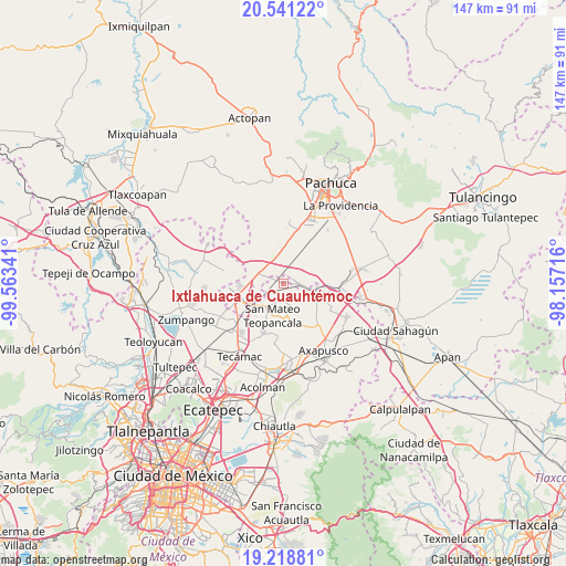
| Upper-left | 20.54122°, | -99.56341° |
| Center: | 19.88139°, | -98.86028° |
| Lower-right: | 19.21881°, | -98.15716° |
| Map W x H: | 147×147 km | = 91.3×91.3mi |
| max Lat: | 32.7° ⇑45.3% North |
| Ixtlahuaca de Cuauhtémoc: | 19.88139° |
| min Lat: | ⇓54.7% South 14.53588° |
| min Long | Ixtlahuaca de C | max Long |
| -117.105° | -98.86028° | -86.73105° |
| W 52.6%⇐ | ⇒47.4% E |
Elevation
Elevation of Ixtlahuaca de Cuauhtémoc is 2320 m = 7612 ft, and this is 1066.3 m = 3498 ft above average elevation for this country.
| Max E: |
3497 m = 11473 ft | 12.7% |
| Ixtlahuaca de Cuauhtémoc | 2320 m 7612 ft | |
| Avg. | 1253.7 m = 4113 ft | |
Min E: |
-1 m = -3 ft | 87.3% |
See also: Mexico elevation on elevation.city.
Geographical zone
Ixtlahuaca de Cuauhtémoc is located in North Torrid zone (between Equator and Tropic of Cancer). Distance of this Northern Tropic circle is 395.3 km =245.6 mi to North.| Distance of | km | miles | from Ixtlahuaca de Cuauhtémoc |
|---|---|---|---|
| North Pole | 7796.5 | 4844.5 | to North |
| Arctic Circle | 5190.6 | 3225.3 | to North |
| Tropic Cancer | 395.3 | 245.6 | to North |
| Equator | 2210.6 | 1373.6 | to South |


Nearby cities:
15 places around Ixtlahuaca de Cuauhtémoc: (largest is in red/bold)
• Barrio de Belén
4 km =2.5 mi,  168°
168°
• Colonia Benito Juárez
5.7 km =3.5 mi,  80°
80°
• Colonia Morelos
4.7 km =2.9 mi, 77°
• Don Antonio
7.8 km =4.8 mi,  264°
264°
• El Cid
7.1 km =4.4 mi, 257°
• General Felipe Ángeles (Los Ángeles)
7.1 km =4.4 mi,  284°
284°
• Las Pintas
3.3 km =2.1 mi,  301°
301°
• Olmos
7 km =4.3 mi,  268°
268°
• Presa del Rey
5.1 km =3.2 mi,  244°
244°
• San Antonio Coayuca
6.7 km =4.2 mi,  118°
118°
• Teacalco
8.5 km =5.3 mi, 174°
• Temascalapa
7.4 km =4.6 mi,  215°
215°
• Teopancala
8.7 km =5.4 mi,  198°
198°
• Tezontepec
4.2 km =2.6 mi,  91°
91°
• Vicente Guerrero (San Javier)
8.7 km =5.4 mi,  330°
330°
Sources, notices
• [Note1] Compared only with cities in Mexico existing in our database
• [Src1] Map data: © OpenStreetMap contributors (CC-BY-SA)
• [Src2] Other city data from geonames.org with taken over terms of usage.
• [Src3] Geographical zone / Annual Mean Temperature by Robert A. Rohde @ Wikipedia
