Teopancala geodata
Teopancala (Hidalgo) is a populated place; located in Mexico in America/Mexico_City (GMT-6) time zone. With population of 973 people, there are 8931 cities with bigger population in this country. Compared to other cities in Mexico, 53% of cities are located further ↓South; 52.2% of cities are located further ←West and 89.6% of cities have lower elevation than Teopancala. Note1


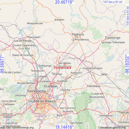
Teopancala GPS coordinates[2]
19° 48' 25.38" North, 98° 53' 11.904" West
| Map corner | latitude | longitude |
|---|---|---|
| Upper-left | 20.46719°, | -99.58977° |
| Center: | 19.80705°, | -98.88664° |
| Lower-right: | 19.14416°, | -98.18352° |
| Map W x H: | 147.1×147.1 km | = 91.4×91.4mi |
| max Lat: | 32.7° ⇑47% North |
| Teopancala: | 19.80705° |
| min Lat: | ⇓53% South 14.53588° |
| min Long | Teopancala | max Long |
| -117.105° | -98.88664° | -86.73105° |
| W 52.2%⇐ | ⇒47.8% E |
Elevation
Elevation of Teopancala is 2391 m = 7844 ft, and this is 1137.3 m = 3731 ft above average elevation for this country.
| Max E: |
3497 m = 11473 ft | 10.4% |
| Teopancala | 2391 m 7844 ft | |
| Avg. | 1253.7 m = 4113 ft | |
Min E: |
-1 m = -3 ft | 89.6% |
See also: Mexico elevation on elevation.city.
Geographical zone
Teopancala is located in North Torrid zone (between Equator and Tropic of Cancer). Distance of this Northern Tropic circle is 403.6 km =250.8 mi to North.| Distance of | km | miles | from Teopancala |
|---|---|---|---|
| North Pole | 7804.7 | 4849.6 | to North |
| Arctic Circle | 5198.8 | 3230.4 | to North |
| Tropic Cancer | 403.6 | 250.8 | to North |
| Equator | 2202.3 | 1368.4 | to South |


Nearby cities:
15 places around Teopancala: (largest is in red/bold)
• Barrio de Belén
5.6 km =3.5 mi,  39°
39°
• El Cid
7.9 km =4.9 mi,  327°
327°
• Huitzila
7.3 km =4.5 mi,  273°
273°
• Ixtlahuaca
7.7 km =4.8 mi,  172°
172°
• Ixtlahuaca de Cuauhtémoc
8.7 km =5.4 mi,  18°
18°
• Presa del Rey
6.3 km =3.9 mi,  342°
342°
• San Agustín Actipac
8.4 km =5.2 mi,  187°
187°
• San Cristóbal Colhuacán
7.5 km =4.7 mi,  116°
116°
• San Luis Tecuhautitlán
4.4 km =2.7 mi,  182°
182°
• San Miguel Atlamajac
8.1 km =5 mi,  217°
217°
• Santa Ana Tlachiahualpa
4.9 km =3 mi,  208°
208°
• Santa María Palapa
8.9 km =5.5 mi,  153°
153°
• Teacalco
3.6 km =2.2 mi,  92°
92°
• Temascalapa
2.8 km =1.7 mi, 325°
• Tepojaco
7.4 km =4.6 mi,  300°
300°
Sources, notices
• [Note1] Compared only with cities in Mexico existing in our database
• [Src1] Map data: © OpenStreetMap contributors (CC-BY-SA)
• [Src2] Other city data from geonames.org with taken over terms of usage.
• [Src3] Geographical zone / Annual Mean Temperature by Robert A. Rohde @ Wikipedia
