El Cid geodata
El Cid (Hidalgo) is a populated place; located in Mexico in America/Mexico_City (GMT-6) time zone. With population of 2,578 people, there are 3437 cities with bigger population in this country. Compared to other cities in Mexico, 54.4% of cities are located further ↓South; 51.5% of cities are located further ←West and 87.6% of cities have lower elevation than El Cid. Note1


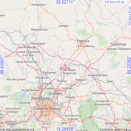
El Cid GPS coordinates[2]
19° 52' 1.992" North, 98° 55' 36.984" West
| Map corner | latitude | longitude |
|---|---|---|
| Upper-left | 20.52711°, | -99.63007° |
| Center: | 19.86722°, | -98.92694° |
| Lower-right: | 19.20458°, | -98.22382° |
| Map W x H: | 147.1×147.1 km | = 91.4×91.4mi |
| max Lat: | 32.7° ⇑45.6% North |
| El Cid: | 19.86722° |
| min Lat: | ⇓54.4% South 14.53588° |
| min Long | El Cid | max Long |
| -117.105° | -98.92694° | -86.73105° |
| W 51.5%⇐ | ⇒48.5% E |
Elevation
Elevation of El Cid is 2329 m = 7641 ft, and this is 1075.3 m = 3528 ft above average elevation for this country.
| Max E: |
3497 m = 11473 ft | 12.4% |
| El Cid | 2329 m 7641 ft | |
| Avg. | 1253.7 m = 4113 ft | |
Min E: |
-1 m = -3 ft | 87.6% |
See also: Mexico elevation on elevation.city.
Geographical zone
El Cid is located in North Torrid zone (between Equator and Tropic of Cancer). Distance of this Northern Tropic circle is 396.9 km =246.6 mi to North.| Distance of | km | miles | from El Cid |
|---|---|---|---|
| North Pole | 7798 | 4845.5 | to North |
| Arctic Circle | 5192.1 | 3226.2 | to North |
| Tropic Cancer | 396.9 | 246.6 | to North |
| Equator | 2209 | 1372.6 | to South |


Nearby cities:
15 places around El Cid: (largest is in red/bold)
• Don Antonio
1.1 km =0.7 mi,  314°
314°
• El Carmen
3.9 km =2.4 mi, 305°
• Ex-Hacienda de Guadalupe
8 km =5 mi,  216°
216°
• Ex-Presidentes
4 km =2.5 mi,  250°
250°
• General Felipe Ángeles (Los Ángeles)
3.4 km =2.1 mi,  1°
1°
• Huitzila
6.9 km =4.3 mi,  205°
205°
• Ixtlahuaca de Cuauhtémoc
7.1 km =4.4 mi,  77°
77°
• Las Pintas
5.3 km =3.3 mi,  51°
51°
• Las Plazas
1.8 km =1.1 mi,  282°
282°
• Olmos
1.4 km =0.9 mi, 0°
• Presa del Rey
2.4 km =1.5 mi,  104°
104°
• Temascalapa
5.1 km =3.2 mi,  149°
149°
• Teopancala
7.9 km =4.9 mi, 147°
• Tepojaco
3.7 km =2.3 mi, 216°
• Tizayuca
6.1 km =3.8 mi,  236°
236°
Sources, notices
• [Note1] Compared only with cities in Mexico existing in our database
• [Src1] Map data: © OpenStreetMap contributors (CC-BY-SA)
• [Src2] Other city data from geonames.org with taken over terms of usage.
• [Src3] Geographical zone / Annual Mean Temperature by Robert A. Rohde @ Wikipedia
