Llano de la Puerta geodata
Llano de la Puerta (Guerrero) is a populated place; located in Mexico in America/Mexico_City (GMT-6) time zone. With population of 1,322 people, there are 6565 cities with bigger population in this country. Compared to other cities in Mexico, 92.3% of cities are located further ↑North; 57.3% of cities are located further →East and 81.6% of cities have higher elevation than Llano de la Puerta. Note1


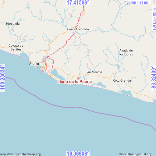
Llano de la Puerta GPS coordinates[2]
16° 44' 36.78" North, 99° 31' 37.956" West
| Map corner | latitude | longitude |
|---|---|---|
| Upper-left | 17.41566°, | -100.23034° |
| Center: | 16.74355°, | -99.52721° |
| Lower-right: | 16.06906°, | -98.82409° |
| Map W x H: | 149.7×149.7 km | = 93×93mi |
| max Lat: | 32.7° ⇑92.3% North |
| Llano de la Puerta: | 16.74355° |
| min Lat: | ⇓7.7% South 14.53588° |
| min Long | Llano de la Pue | max Long |
| -117.105° | -99.52721° | -86.73105° |
| W 42.7%⇐ | ⇒57.3% E |
Elevation
Elevation of Llano de la Puerta is 75 m = 246 ft, and this is 1178.7 m = 3867 ft below average elevation for this country.
| Max E: |
3497 m = 11473 ft | 81.6% |
| Avg. | 1253.7 m = 4113 ft | |
| Llano de la Puerta | 75 m = 246 ft | |
Min E: |
-1 m = -3 ft | 18.4% |
See also: Mexico elevation on elevation.city.
Geographical zone
Llano de la Puerta is located in North Torrid zone (between Equator and Tropic of Cancer). Distance of this Northern Tropic circle is 744.2 km =462.4 mi to North.| Distance of | km | miles | from Llano de la Puerta |
|---|---|---|---|
| North Pole | 8145.4 | 5061.3 | to North |
| Arctic Circle | 5539.5 | 3442.1 | to North |
| Tropic Cancer | 744.2 | 462.4 | to North |
| Equator | 1861.7 | 1156.8 | to South |


Nearby cities:
15 places around Llano de la Puerta: (largest is in red/bold)
• Apalani
13.9 km =8.6 mi,  331°
331°
• Barra Vieja
12.1 km =7.5 mi,  241°
241°
• Bella Vista Papagayo
8.5 km =5.3 mi,  293°
293°
• Campanario
11.3 km =7 mi,  335°
335°
• Cerro de Piedra
11.6 km =7.2 mi, 288°
• El Cocoyult (Coacoyul)
4.4 km =2.7 mi,  64°
64°
• El Cortés
4.9 km =3 mi,  32°
32°
• El Tamarindo
11.9 km =7.4 mi,  6°
6°
• Las Cruces de Cacahuatepec
14.9 km =9.3 mi,  320°
320°
• Las Minas
6.9 km =4.3 mi,  348°
348°
• Lomas de Chapultepec
9.3 km =5.8 mi,  250°
250°
• Monte Alto
7.2 km =4.5 mi,  113°
113°
• San Andrés Playa Encantada (El Podrido)
12.7 km =7.9 mi, 243°
• Tasajeras
12 km =7.5 mi,  307°
307°
• Tecomate Nanchal
8.1 km =5 mi,  15°
15°
Sources, notices
• [Note1] Compared only with cities in Mexico existing in our database
• [Src1] Map data: © OpenStreetMap contributors (CC-BY-SA)
• [Src2] Other city data from geonames.org with taken over terms of usage.
• [Src3] Geographical zone / Annual Mean Temperature by Robert A. Rohde @ Wikipedia
