Tecomate Nanchal geodata
Tecomate Nanchal (Guerrero) is a populated place; located in Mexico in America/Mexico_City (GMT-6) time zone. With population of 515 people, there are 16340 cities with bigger population in this country. Compared to other cities in Mexico, 91.5% of cities are located further ↑North; 57.1% of cities are located further →East and 80% of cities have higher elevation than Tecomate Nanchal. Note1


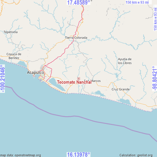
Tecomate Nanchal GPS coordinates[2]
16° 48' 50.508" North, 99° 30' 26.388" West
| Map corner | latitude | longitude |
|---|---|---|
| Upper-left | 17.48589°, | -100.21046° |
| Center: | 16.81403°, | -99.50733° |
| Lower-right: | 16.13978°, | -98.80421° |
| Map W x H: | 149.7×149.7 km | = 93×93mi |
| max Lat: | 32.7° ⇑91.5% North |
| Tecomate Nanchal: | 16.81403° |
| min Lat: | ⇓8.5% South 14.53588° |
| min Long | Tecomate Nancha | max Long |
| -117.105° | -99.50733° | -86.73105° |
| W 42.9%⇐ | ⇒57.1% E |
Elevation
Elevation of Tecomate Nanchal is 95 m = 312 ft, and this is 1158.7 m = 3802 ft below average elevation for this country.
| Max E: |
3497 m = 11473 ft | 80% |
| Avg. | 1253.7 m = 4113 ft | |
| Tecomate Nanchal | 95 m = 312 ft | |
Min E: |
-1 m = -3 ft | 20% |
See also: Mexico elevation on elevation.city.
Geographical zone
Tecomate Nanchal is located in North Torrid zone (between Equator and Tropic of Cancer). Distance of this Northern Tropic circle is 736.4 km =457.6 mi to North.| Distance of | km | miles | from Tecomate Nanchal |
|---|---|---|---|
| North Pole | 8137.5 | 5056.4 | to North |
| Arctic Circle | 5531.6 | 3437.2 | to North |
| Tropic Cancer | 736.4 | 457.6 | to North |
| Equator | 1869.5 | 1161.7 | to South |


Nearby cities:
15 places around Tecomate Nanchal: (largest is in red/bold)
• Apalani
9.8 km =6.1 mi,  296°
296°
• Barrio Nuevo de los Muertos
9.6 km =6 mi,  336°
336°
• Bella Vista Papagayo
10.9 km =6.8 mi,  245°
245°
• Campanario
7.3 km =4.5 mi,  289°
289°
• El Cantón
13.1 km =8.1 mi,  312°
312°
• El Cocoyult (Coacoyul)
6.2 km =3.9 mi,  162°
162°
• El Cortés
3.8 km =2.4 mi,  171°
171°
• El Tamarindo
4.1 km =2.5 mi,  347°
347°
• Las Cruces de Cacahuatepec
12.2 km =7.6 mi, 287°
• Las Minas
3.6 km =2.2 mi, 252°
• Llano de la Puerta
8.1 km =5 mi,  195°
195°
• Monte Alto
11.6 km =7.2 mi, 157°
• Piedra Blanca
10.4 km =6.5 mi,  3°
3°
• San Marcos
12.7 km =7.9 mi,  98°
98°
• Tasajeras
11.6 km =7.2 mi,  267°
267°
Sources, notices
• [Note1] Compared only with cities in Mexico existing in our database
• [Src1] Map data: © OpenStreetMap contributors (CC-BY-SA)
• [Src2] Other city data from geonames.org with taken over terms of usage.
• [Src3] Geographical zone / Annual Mean Temperature by Robert A. Rohde @ Wikipedia
