Vallehermoso geodata
Vallehermoso (Quintana Roo) is a populated place; located in Mexico in America/Cancun (GMT-5) time zone. With population of 545 people, there are 15598 cities with bigger population in this country. Compared to other cities in Mexico, 61.5% of cities are located further ↑North; 99.3% of cities are located further ←West and 89.4% of cities have higher elevation than Vallehermoso. Note1


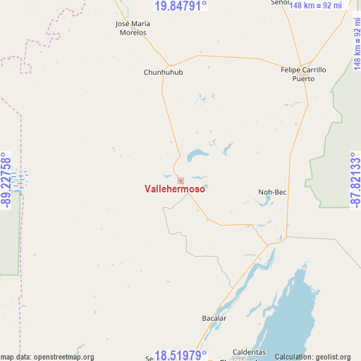
Vallehermoso GPS coordinates[2]
19° 11' 6.684" North, 88° 31' 28.02" West
| Map corner | latitude | longitude |
|---|---|---|
| Upper-left | 19.84791°, | -89.22758° |
| Center: | 19.18519°, | -88.52445° |
| Lower-right: | 18.51979°, | -87.82133° |
| Map W x H: | 147.7×147.7 km | = 91.8×91.8mi |
| max Lat: | 32.7° ⇑61.5% North |
| Vallehermoso: | 19.18519° |
| min Lat: | ⇓38.5% South 14.53588° |
| min Long | Vallehermoso | max Long |
| -117.105° | -88.52445° | -86.73105° |
| W 99.3%⇐ | ⇒0.7% E |
Elevation
Elevation of Vallehermoso is 26 m = 85 ft, and this is 1227.7 m = 4028 ft below average elevation for this country.
| Max E: |
3497 m = 11473 ft | 89.4% |
| Avg. | 1253.7 m = 4113 ft | |
| Vallehermoso | 26 m = 85 ft | |
Min E: |
-1 m = -3 ft | 10.6% |
See also: Mexico elevation on elevation.city.
Geographical zone
Vallehermoso is located in North Torrid zone (between Equator and Tropic of Cancer). Distance of this Northern Tropic circle is 472.7 km =293.7 mi to North.| Distance of | km | miles | from Vallehermoso |
|---|---|---|---|
| North Pole | 7873.9 | 4892.6 | to North |
| Arctic Circle | 5268 | 3273.4 | to North |
| Tropic Cancer | 472.7 | 293.7 | to North |
| Equator | 2133.2 | 1325.5 | to South |


Nearby cities:
15 places around Vallehermoso: (largest is in red/bold)
• Altos de Sevilla
40.4 km =25.1 mi,  203°
203°
• Chan Santa Cruz
28.7 km =17.8 mi,  44°
44°
• Chunhuhub
45.1 km =28 mi,  350°
350°
• Ignacio Manuel Altamirano
12.7 km =7.9 mi,  335°
335°
• La Pantera
6 km =3.7 mi,  145°
145°
• Laguna Kaná
37.8 km =23.5 mi,  20°
20°
• Los Divorciados
14 km =8.7 mi, 149°
• Maya Balam
30.3 km =18.8 mi, 154°
• Miguel Hidalgo y Costilla
43.5 km =27 mi, 154°
• Naranjal Poniente
20.8 km =12.9 mi, 18°
• Polyuc
47.3 km =29.4 mi,  355°
355°
• Presidente Juárez
16.4 km =10.2 mi, 346°
• Reforma
41.6 km =25.8 mi,  186°
186°
• San Isidro la Laguna
44.6 km =27.7 mi,  158°
158°
• Santa María Poniente
23.7 km =14.7 mi,  31°
31°
Sources, notices
• [Note1] Compared only with cities in Mexico existing in our database
• [Src1] Map data: © OpenStreetMap contributors (CC-BY-SA)
• [Src2] Other city data from geonames.org with taken over terms of usage.
• [Src3] Geographical zone / Annual Mean Temperature by Robert A. Rohde @ Wikipedia
