Reforma geodata
Reforma (Quintana Roo) is a populated place; located in Mexico in America/Cancun (GMT-5) time zone. With population of 992 people, there are 8782 cities with bigger population in this country. Compared to other cities in Mexico, 68.5% of cities are located further ↑North; 99.2% of cities are located further ←West and 90.4% of cities have higher elevation than Reforma. Note1


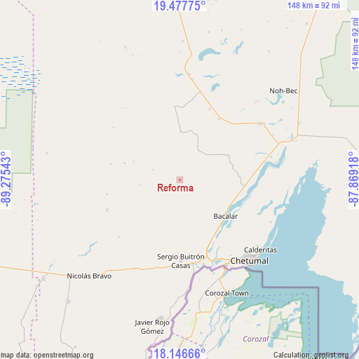
Reforma GPS coordinates[2]
18° 48' 48.672" North, 88° 34' 20.28" West
| Map corner | latitude | longitude |
|---|---|---|
| Upper-left | 19.47775°, | -89.27543° |
| Center: | 18.81352°, | -88.5723° |
| Lower-right: | 18.14666°, | -87.86918° |
| Map W x H: | 148×148 km | = 92×92mi |
| max Lat: | 32.7° ⇑68.5% North |
| Reforma: | 18.81352° |
| min Lat: | ⇓31.5% South 14.53588° |
| min Long | Reforma | max Long |
| -117.105° | -88.5723° | -86.73105° |
| W 99.2%⇐ | ⇒0.8% E |
Elevation
Elevation of Reforma is 23 m = 75 ft, and this is 1230.7 m = 4038 ft below average elevation for this country.
| Max E: |
3497 m = 11473 ft | 90.4% |
| Avg. | 1253.7 m = 4113 ft | |
| Reforma | 23 m = 75 ft | |
Min E: |
-1 m = -3 ft | 9.6% |
See also: Mexico elevation on elevation.city.
Geographical zone
Reforma is located in North Torrid zone (between Equator and Tropic of Cancer). Distance of this Northern Tropic circle is 514.1 km =319.4 mi to North.| Distance of | km | miles | from Reforma |
|---|---|---|---|
| North Pole | 7915.2 | 4918.3 | to North |
| Arctic Circle | 5309.3 | 3299 | to North |
| Tropic Cancer | 514.1 | 319.4 | to North |
| Equator | 2091.9 | 1299.8 | to South |


Nearby cities:
15 places around Reforma: (largest is in red/bold)
• Altos de Sevilla
11.8 km =7.3 mi,  291°
291°
• Bacalar
23.9 km =14.9 mi,  128°
128°
• Laguna Guerrero
34.9 km =21.7 mi,  113°
113°
• Los Divorciados
31.7 km =19.7 mi,  22°
22°
• Lázaro Cárdenas Segundo
32.6 km =20.3 mi,  247°
247°
• Maya Balam
22.9 km =14.2 mi,  52°
52°
• Miguel Hidalgo y Costilla
24.1 km =15 mi,  84°
84°
• Morocoy
34.3 km =21.3 mi,  227°
227°
• Salamanca
18.7 km =11.6 mi,  145°
145°
• San Isidro la Laguna
21.2 km =13.2 mi,  90°
90°
• San Pedro Peralta
32.4 km =20.1 mi, 247°
• San Román
16.5 km =10.3 mi,  262°
262°
• Sergio Butrón Casas
33.3 km =20.7 mi,  179°
179°
• Ucum
35 km =21.7 mi,  170°
170°
• Xul-Ha
31.3 km =19.4 mi,  158°
158°
Sources, notices
• [Note1] Compared only with cities in Mexico existing in our database
• [Src1] Map data: © OpenStreetMap contributors (CC-BY-SA)
• [Src2] Other city data from geonames.org with taken over terms of usage.
• [Src3] Geographical zone / Annual Mean Temperature by Robert A. Rohde @ Wikipedia
