Lázaro Cárdenas geodata
Lázaro Cárdenas (Veracruz) is a populated place; located in Mexico in America/Mexico_City (GMT-6) time zone. With population of 600 people, there are 14337 cities with bigger population in this country. Compared to other cities in Mexico, 85.5% of cities are located further ↓South; 61.6% of cities are located further ←West and 87% of cities have higher elevation than Lázaro Cárdenas. Note1


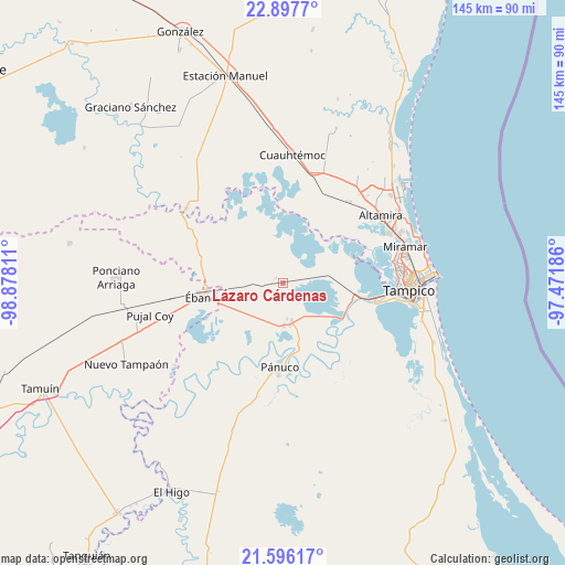
Lázaro Cárdenas GPS coordinates[2]
22° 14' 54.42" North, 98° 10' 29.928" West
| Map corner | latitude | longitude |
|---|---|---|
| Upper-left | 22.8977°, | -98.87811° |
| Center: | 22.24845°, | -98.17498° |
| Lower-right: | 21.59617°, | -97.47186° |
| Map W x H: | 144.7×144.7 km | = 89.9×89.9mi |
| max Lat: | 32.7° ⇑14.5% North |
| Lázaro Cárdenas: | 22.24845° |
| min Lat: | ⇓85.5% South 14.53588° |
| min Long | Lázaro Cárden | max Long |
| -117.105° | -98.17498° | -86.73105° |
| W 61.6%⇐ | ⇒38.4% E |
Elevation
Elevation of Lázaro Cárdenas is 34 m = 112 ft, and this is 1219.7 m = 4002 ft below average elevation for this country.
| Max E: |
3497 m = 11473 ft | 87% |
| Avg. | 1253.7 m = 4113 ft | |
| Lázaro Cárdenas | 34 m = 112 ft | |
Min E: |
-1 m = -3 ft | 13% |
See also: Mexico elevation on elevation.city.
Geographical zone
Lázaro Cárdenas is located in North Torrid zone (between Equator and Tropic of Cancer). Distance of this Northern Tropic circle is 132.1 km =82.1 mi to North.| Distance of | km | miles | from Lázaro Cárdenas |
|---|---|---|---|
| North Pole | 7533.3 | 4681 | to North |
| Arctic Circle | 4927.4 | 3061.7 | to North |
| Tropic Cancer | 132.1 | 82.1 | to North |
| Equator | 2473.8 | 1537.1 | to South |


Nearby cities:
15 places around Lázaro Cárdenas: (largest is in red/bold)
• Antonio J Bermúdez
11 km =6.8 mi,  171°
171°
• Buenavista
18.1 km =11.2 mi, 171°
• Calentadores
11.8 km =7.3 mi,  133°
133°
• Chijol Diecisiete
10.2 km =6.3 mi,  271°
271°
• Colonia Piloto
21.9 km =13.6 mi,  297°
297°
• Confederación Nacional Campesina
9.7 km =6 mi, 166°
• Emiliano Zapata
18.4 km =11.4 mi,  115°
115°
• Miravegas
18.5 km =11.5 mi,  136°
136°
• Paso Real
20.8 km =12.9 mi,  179°
179°
• Perseverancia
18.7 km =11.6 mi,  99°
99°
• Pánuco
21.7 km =13.5 mi, 182°
• Reventadero
14.8 km =9.2 mi,  190°
190°
• Tampuche
19.8 km =12.3 mi, 173°
• Vega de Otates
19.5 km =12.1 mi,  157°
157°
• Ébano
21.1 km =13.1 mi,  260°
260°
Sources, notices
• [Note1] Compared only with cities in Mexico existing in our database
• [Src1] Map data: © OpenStreetMap contributors (CC-BY-SA)
• [Src2] Other city data from geonames.org with taken over terms of usage.
• [Src3] Geographical zone / Annual Mean Temperature by Robert A. Rohde @ Wikipedia
