Calentadores geodata
Calentadores (Veracruz) is a populated place; located in Mexico in America/Mexico_City (GMT-6) time zone. With population of 570 people, there are 15008 cities with bigger population in this country. Compared to other cities in Mexico, 85.1% of cities are located further ↓South; 62.6% of cities are located further ←West and 98.1% of cities have higher elevation than Calentadores. Note1


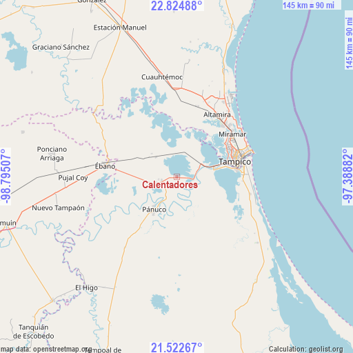
Calentadores GPS coordinates[2]
22° 10' 31.008" North, 98° 5' 30.984" West
| Map corner | latitude | longitude |
|---|---|---|
| Upper-left | 22.82488°, | -98.79507° |
| Center: | 22.17528°, | -98.09194° |
| Lower-right: | 21.52267°, | -97.38882° |
| Map W x H: | 144.8×144.8 km | = 90×90mi |
| max Lat: | 32.7° ⇑14.9% North |
| Calentadores: | 22.17528° |
| min Lat: | ⇓85.1% South 14.53588° |
| min Long | Calentadores | max Long |
| -117.105° | -98.09194° | -86.73105° |
| W 62.6%⇐ | ⇒37.4% E |
Elevation
Elevation of Calentadores is 8 m = 26 ft, and this is 1245.7 m = 4087 ft below average elevation for this country.
| Max E: |
3497 m = 11473 ft | 98.1% |
| Avg. | 1253.7 m = 4113 ft | |
| Calentadores | 8 m = 26 ft | |
Min E: |
-1 m = -3 ft | 1.9% |
See also: Mexico elevation on elevation.city.
Geographical zone
Calentadores is located in North Torrid zone (between Equator and Tropic of Cancer). Distance of this Northern Tropic circle is 140.3 km =87.2 mi to North.| Distance of | km | miles | from Calentadores |
|---|---|---|---|
| North Pole | 7541.4 | 4686 | to North |
| Arctic Circle | 4935.5 | 3066.8 | to North |
| Tropic Cancer | 140.3 | 87.2 | to North |
| Equator | 2465.7 | 1532.1 | to South |


Nearby cities:
15 places around Calentadores: (largest is in red/bold)
• Antonio J Bermúdez
7.4 km =4.6 mi,  248°
248°
• Buenavista
11.4 km =7.1 mi,  210°
210°
• Chijol Diecisiete
20.5 km =12.7 mi,  293°
293°
• Confederación Nacional Campesina
6.4 km =4 mi,  258°
258°
• El Crucero (Estación Pedernales)
14.8 km =9.2 mi,  88°
88°
• Emiliano Zapata
8.2 km =5.1 mi, 87°
• Lázaro Cárdenas
11.8 km =7.3 mi,  313°
313°
• Miravegas
6.7 km =4.2 mi,  142°
142°
• Moralillo
19.3 km =12 mi,  73°
73°
• Paso Real
15.2 km =9.4 mi, 213°
• Perseverancia
11 km =6.8 mi,  63°
63°
• Pánuco
16.6 km =10.3 mi,  215°
215°
• Reventadero
13 km =8.1 mi,  240°
240°
• Tampuche
13.1 km =8.1 mi, 208°
• Vega de Otates
9.8 km =6.1 mi,  185°
185°
Sources, notices
• [Note1] Compared only with cities in Mexico existing in our database
• [Src1] Map data: © OpenStreetMap contributors (CC-BY-SA)
• [Src2] Other city data from geonames.org with taken over terms of usage.
• [Src3] Geographical zone / Annual Mean Temperature by Robert A. Rohde @ Wikipedia
