Paso Real geodata
Paso Real (Veracruz) is a populated place; located in Mexico in America/Mexico_City (GMT-6) time zone. With population of 945 people, there are 9215 cities with bigger population in this country. Compared to other cities in Mexico, 84.5% of cities are located further ↓South; 61.6% of cities are located further ←West and 96.3% of cities have higher elevation than Paso Real. Note1


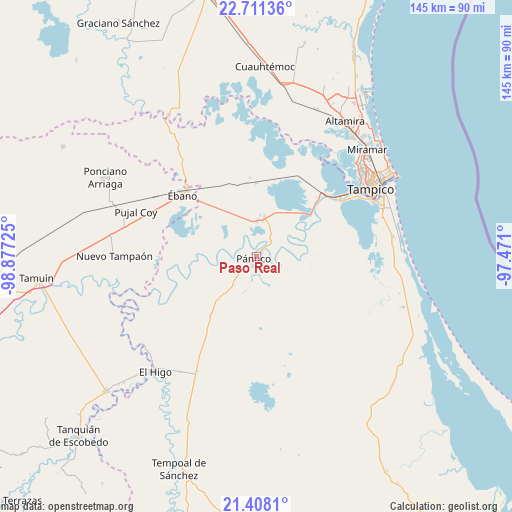
Paso Real GPS coordinates[2]
22° 3' 40.428" North, 98° 10' 26.832" West
| Map corner | latitude | longitude |
|---|---|---|
| Upper-left | 22.71136°, | -98.87725° |
| Center: | 22.06123°, | -98.17412° |
| Lower-right: | 21.4081°, | -97.471° |
| Map W x H: | 144.9×144.9 km | = 90×90mi |
| max Lat: | 32.7° ⇑15.5% North |
| Paso Real: | 22.06123° |
| min Lat: | ⇓84.5% South 14.53588° |
| min Long | Paso Real | max Long |
| -117.105° | -98.17412° | -86.73105° |
| W 61.6%⇐ | ⇒38.4% E |
Elevation
Elevation of Paso Real is 11 m = 36 ft, and this is 1242.7 m = 4077 ft below average elevation for this country.
| Max E: |
3497 m = 11473 ft | 96.3% |
| Avg. | 1253.7 m = 4113 ft | |
| Paso Real | 11 m = 36 ft | |
Min E: |
-1 m = -3 ft | 3.7% |
See also: Mexico elevation on elevation.city.
Geographical zone
Paso Real is located in North Torrid zone (between Equator and Tropic of Cancer). Distance of this Northern Tropic circle is 152.9 km =95 mi to North.| Distance of | km | miles | from Paso Real |
|---|---|---|---|
| North Pole | 7554.1 | 4693.9 | to North |
| Arctic Circle | 4948.2 | 3074.7 | to North |
| Tropic Cancer | 152.9 | 95 | to North |
| Equator | 2453 | 1524.2 | to South |


Nearby cities:
15 places around Paso Real: (largest is in red/bold)
• Antonio J Bermúdez
10 km =6.2 mi,  9°
9°
• Aquiles Serdán
21.2 km =13.2 mi,  172°
172°
• Buenavista
3.9 km =2.4 mi,  41°
41°
• Calentadores
15.2 km =9.4 mi,  33°
33°
• Confederación Nacional Campesina
11.6 km =7.2 mi, 11°
• El Molino
20.6 km =12.8 mi,  218°
218°
• Emiliano Zapata
21.1 km =13.1 mi,  51°
51°
• Lázaro Cárdenas
20.8 km =12.9 mi,  359°
359°
• Miravegas
14.5 km =9 mi,  59°
59°
• Oviedo
23.4 km =14.5 mi,  265°
265°
• Pánuco
1.4 km =0.9 mi,  233°
233°
• Pánuco (La Pitahaya) [Nuevo Centro de Población]
13.3 km =8.3 mi,  163°
163°
• Reventadero
6.9 km =4.3 mi,  335°
335°
• Tampuche
2.6 km =1.6 mi, 63°
• Vega de Otates
8.1 km =5 mi,  68°
68°
Sources, notices
• [Note1] Compared only with cities in Mexico existing in our database
• [Src1] Map data: © OpenStreetMap contributors (CC-BY-SA)
• [Src2] Other city data from geonames.org with taken over terms of usage.
• [Src3] Geographical zone / Annual Mean Temperature by Robert A. Rohde @ Wikipedia
