La Camelia geodata
La Camelia (Veracruz) is a populated place; located in Mexico in America/Mexico_City (GMT-6) time zone. With population of 2,153 people, there are 4080 cities with bigger population in this country. Compared to other cities in Mexico, 74.8% of cities are located further ↓South; 66.4% of cities are located further ←West and 84.3% of cities have higher elevation than La Camelia. Note1


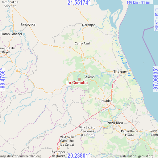
La Camelia GPS coordinates[2]
20° 53' 46.716" North, 97° 46' 20.892" West
| Map corner | latitude | longitude |
|---|---|---|
| Upper-left | 21.55174°, | -98.4756° |
| Center: | 20.89631°, | -97.77247° |
| Lower-right: | 20.23801°, | -97.06935° |
| Map W x H: | 146.1×146.1 km | = 90.8×90.8mi |
| max Lat: | 32.7° ⇑25.2% North |
| La Camelia: | 20.89631° |
| min Lat: | ⇓74.8% South 14.53588° |
| min Long | La Camelia | max Long |
| -117.105° | -97.77247° | -86.73105° |
| W 66.4%⇐ | ⇒33.6% E |
Elevation
Elevation of La Camelia is 50 m = 164 ft, and this is 1203.7 m = 3949 ft below average elevation for this country.
| Max E: |
3497 m = 11473 ft | 84.3% |
| Avg. | 1253.7 m = 4113 ft | |
| La Camelia | 50 m = 164 ft | |
Min E: |
-1 m = -3 ft | 15.7% |
See also: Mexico elevation on elevation.city.
Geographical zone
La Camelia is located in North Torrid zone (between Equator and Tropic of Cancer). Distance of this Northern Tropic circle is 282.5 km =175.5 mi to North.| Distance of | km | miles | from La Camelia |
|---|---|---|---|
| North Pole | 7683.6 | 4774.4 | to North |
| Arctic Circle | 5077.7 | 3155.1 | to North |
| Tropic Cancer | 282.5 | 175.5 | to North |
| Equator | 2323.5 | 1443.8 | to South |


Nearby cities:
15 places around La Camelia: (largest is in red/bold)
• Agua Nacida
7.1 km =4.4 mi,  73°
73°
• Ejido La Noria
5.1 km =3.2 mi,  331°
331°
• Emiliano Zapata
6.5 km =4 mi,  123°
123°
• Estación Chapapote (Puerta Siete)
7.6 km =4.7 mi,  42°
42°
• La Tortuga
8.5 km =5.3 mi,  78°
78°
• Las Flores Cinco Poblados
4.1 km =2.5 mi,  349°
349°
• Monte Chiquito
8 km =5 mi,  338°
338°
• Ojital Ciruelo
7 km =4.3 mi,  31°
31°
• Ojital Santa María
6.7 km =4.2 mi,  18°
18°
• Palo Blanco
2.8 km =1.7 mi, 41°
• Paso del Perro
6 km =3.7 mi,  199°
199°
• Puerta Siete
9 km =5.6 mi,  54°
54°
• Rodríguez Clara
4.4 km =2.7 mi,  102°
102°
• Sombrerete Grande
3.9 km =2.4 mi,  260°
260°
• Vegas de la Soledad y Soledad Dos
8.3 km =5.2 mi,  310°
310°
Sources, notices
• [Note1] Compared only with cities in Mexico existing in our database
• [Src1] Map data: © OpenStreetMap contributors (CC-BY-SA)
• [Src2] Other city data from geonames.org with taken over terms of usage.
• [Src3] Geographical zone / Annual Mean Temperature by Robert A. Rohde @ Wikipedia
