Monte Chiquito geodata
Monte Chiquito (Veracruz) is a populated place; located in Mexico in America/Mexico_City (GMT-6) time zone. With population of 541 people, there are 15692 cities with bigger population in this country. Compared to other cities in Mexico, 76% of cities are located further ↓South; 66.1% of cities are located further ←West and 83.6% of cities have higher elevation than Monte Chiquito. Note1


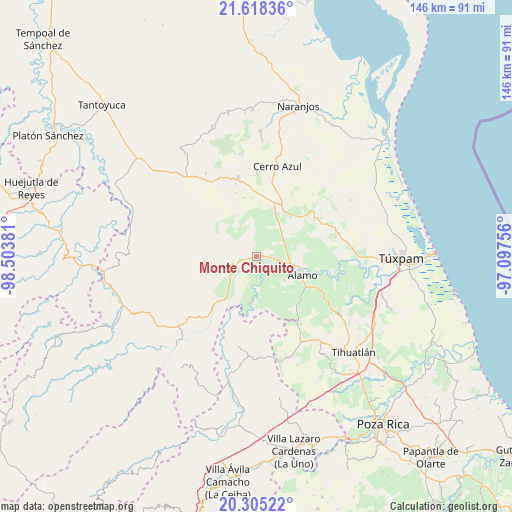
Monte Chiquito GPS coordinates[2]
20° 57' 47.628" North, 97° 48' 2.448" West
| Map corner | latitude | longitude |
|---|---|---|
| Upper-left | 21.61836°, | -98.50381° |
| Center: | 20.96323°, | -97.80068° |
| Lower-right: | 20.30522°, | -97.09756° |
| Map W x H: | 146×146 km | = 90.7×90.7mi |
| max Lat: | 32.7° ⇑24% North |
| Monte Chiquito: | 20.96323° |
| min Lat: | ⇓76% South 14.53588° |
| min Long | Monte Chiquito | max Long |
| -117.105° | -97.80068° | -86.73105° |
| W 66.1%⇐ | ⇒33.9% E |
Elevation
Elevation of Monte Chiquito is 54 m = 177 ft, and this is 1199.7 m = 3936 ft below average elevation for this country.
| Max E: |
3497 m = 11473 ft | 83.6% |
| Avg. | 1253.7 m = 4113 ft | |
| Monte Chiquito | 54 m = 177 ft | |
Min E: |
-1 m = -3 ft | 16.4% |
See also: Mexico elevation on elevation.city.
Geographical zone
Monte Chiquito is located in North Torrid zone (between Equator and Tropic of Cancer). Distance of this Northern Tropic circle is 275 km =170.9 mi to North.| Distance of | km | miles | from Monte Chiquito |
|---|---|---|---|
| North Pole | 7676.2 | 4769.8 | to North |
| Arctic Circle | 5070.3 | 3150.5 | to North |
| Tropic Cancer | 275 | 170.9 | to North |
| Equator | 2330.9 | 1448.4 | to South |


Nearby cities:
15 places around Monte Chiquito: (largest is in red/bold)
• Agua Nacida
11.2 km =7 mi,  119°
119°
• Ejido La Noria
3 km =1.9 mi,  170°
170°
• Estación Chapapote (Puerta Siete)
8.2 km =5.1 mi,  102°
102°
• General A. Tejeda y su A. Graciano Sánchez
9.8 km =6.1 mi,  93°
93°
• La Camelia
8 km =5 mi,  158°
158°
• Las Flores Cinco Poblados
4 km =2.5 mi,  147°
147°
• Ojital Ciruelo
6.7 km =4.2 mi, 102°
• Ojital Santa María
5.2 km =3.2 mi, 102°
• Palo Blanco
7.2 km =4.5 mi,  138°
138°
• Puerta Siete
10.5 km =6.5 mi, 102°
• Rodríguez Clara
11.1 km =6.9 mi, 139°
• San Fernando
10.4 km =6.5 mi,  226°
226°
• Sombrerete Grande
8.1 km =5 mi,  186°
186°
• Tierra Blanca Booxter
9.4 km =5.8 mi,  68°
68°
• Vegas de la Soledad y Soledad Dos
3.9 km =2.4 mi,  238°
238°
Sources, notices
• [Note1] Compared only with cities in Mexico existing in our database
• [Src1] Map data: © OpenStreetMap contributors (CC-BY-SA)
• [Src2] Other city data from geonames.org with taken over terms of usage.
• [Src3] Geographical zone / Annual Mean Temperature by Robert A. Rohde @ Wikipedia
