Vegas de la Soledad y Soledad Dos geodata
Vegas de la Soledad y Soledad Dos (Veracruz) is a populated place; located in Mexico in America/Mexico_City (GMT-6) time zone. With population of 1,258 people, there are 6880 cities with bigger population in this country. Compared to other cities in Mexico, 75.6% of cities are located further ↓South; 65.6% of cities are located further ←West and 84.1% of cities have higher elevation than Vegas de la Soledad y Soledad Dos. Note1
Current local time in Vegas de la Soledad y Soledad Dos:
06:51 AM, WednesdayDifference from your time zone: hours


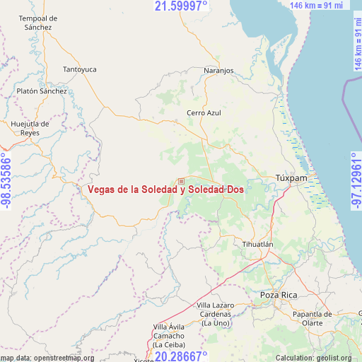
Vegas de la Soledad y Soledad Dos GPS coordinates[2]
20° 56' 41.136" North, 97° 49' 57.828" West
| Map corner | latitude | longitude |
|---|---|---|
| Upper-left | 21.59997°, | -98.53586° |
| Center: | 20.94476°, | -97.83273° |
| Lower-right: | 20.28667°, | -97.12961° |
| Map W x H: | 146×146 km | = 90.7×90.7mi |
| max Lat: | 32.7° ⇑24.4% North |
| Vegas de la Soledad y Soledad Dos: | 20.94476° |
| min Lat: | ⇓75.6% South 14.53588° |
| min Long | Vegas de la Sol | max Long |
| -117.105° | -97.83273° | -86.73105° |
| W 65.6%⇐ | ⇒34.4% E |
Elevation
Elevation of Vegas de la Soledad y Soledad Dos is 51 m = 167 ft, and this is 1202.7 m = 3946 ft below average elevation for this country.
| Max E: |
3497 m = 11473 ft | 84.1% |
| Avg. | 1253.7 m = 4113 ft | |
| Vegas de la Soledad y Soledad Dos | 51 m = 167 ft | |
Min E: |
-1 m = -3 ft | 15.9% |
See also: Mexico elevation on elevation.city.
Geographical zone
Vegas de la Soledad y Soledad Dos is located in North Torrid zone (between Equator and Tropic of Cancer). Distance of this Northern Tropic circle is 277.1 km =172.2 mi to North.| Distance of | km | miles | from Vegas de la Soledad y Soledad Dos |
|---|---|---|---|
| North Pole | 7678.2 | 4771 | to North |
| Arctic Circle | 5072.3 | 3151.8 | to North |
| Tropic Cancer | 277.1 | 172.2 | to North |
| Equator | 2328.8 | 1447 | to South |


Nearby cities:
15 places around Vegas de la Soledad y Soledad Dos: (largest is in red/bold)
• Ejido La Noria
3.9 km =2.4 mi,  102°
102°
• Estación Chapapote (Puerta Siete)
11.4 km =7.1 mi,  88°
88°
• General A. Tejeda y su A. Graciano Sánchez
13.2 km =8.2 mi,  83°
83°
• La Camelia
8.3 km =5.2 mi,  130°
130°
• Las Flores Cinco Poblados
5.6 km =3.5 mi, 103°
• Lomas de Vinazco
10.3 km =6.4 mi,  209°
209°
• Monte Chiquito
3.9 km =2.4 mi,  58°
58°
• Ojital Ciruelo
9.9 km =6.2 mi, 86°
• Ojital Santa María
8.4 km =5.2 mi, 83°
• Palo Blanco
8.7 km =5.4 mi,  112°
112°
• Paso del Perro
11.8 km =7.3 mi,  158°
158°
• Rodríguez Clara
12.3 km =7.6 mi,  121°
121°
• San Fernando
6.6 km =4.1 mi,  219°
219°
• Sombrerete Grande
6.5 km =4 mi, 158°
• Tierra Blanca Booxter
13.3 km =8.3 mi,  65°
65°
Sources, notices
• [Note1] Compared only with cities in Mexico existing in our database
• [Src1] Map data: © OpenStreetMap contributors (CC-BY-SA)
• [Src2] Other city data from geonames.org with taken over terms of usage.
• [Src3] Geographical zone / Annual Mean Temperature by Robert A. Rohde @ Wikipedia
