Hueytepec geodata
Hueytepec (Veracruz) is a populated place; located in Mexico in America/Mexico_City (GMT-6) time zone. With population of 2,395 people, there are 3685 cities with bigger population in this country. Compared to other cities in Mexico, 64.1% of cities are located further ↓South; 74.5% of cities are located further ←West and 88.6% of cities have higher elevation than Hueytepec. Note1


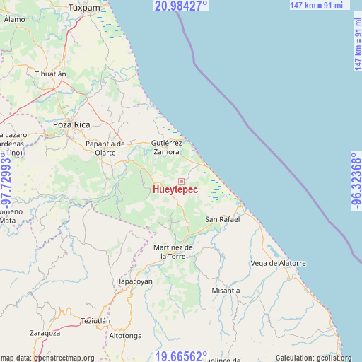
Hueytepec GPS coordinates[2]
20° 19' 34.86" North, 97° 1' 36.48" West
| Map corner | latitude | longitude |
|---|---|---|
| Upper-left | 20.98427°, | -97.72993° |
| Center: | 20.32635°, | -97.0268° |
| Lower-right: | 19.66562°, | -96.32368° |
| Map W x H: | 146.6×146.6 km | = 91.1×91.1mi |
| max Lat: | 32.7° ⇑35.9% North |
| Hueytepec: | 20.32635° |
| min Lat: | ⇓64.1% South 14.53588° |
| min Long | Hueytepec | max Long |
| -117.105° | -97.0268° | -86.73105° |
| W 74.5%⇐ | ⇒25.5% E |
Elevation
Elevation of Hueytepec is 28 m = 92 ft, and this is 1225.7 m = 4021 ft below average elevation for this country.
| Max E: |
3497 m = 11473 ft | 88.6% |
| Avg. | 1253.7 m = 4113 ft | |
| Hueytepec | 28 m = 92 ft | |
Min E: |
-1 m = -3 ft | 11.4% |
See also: Mexico elevation on elevation.city.
Geographical zone
Hueytepec is located in North Torrid zone (between Equator and Tropic of Cancer). Distance of this Northern Tropic circle is 345.8 km =214.9 mi to North.| Distance of | km | miles | from Hueytepec |
|---|---|---|---|
| North Pole | 7747 | 4813.8 | to North |
| Arctic Circle | 5141.1 | 3194.5 | to North |
| Tropic Cancer | 345.8 | 214.9 | to North |
| Equator | 2260.1 | 1404.4 | to South |


Nearby cities:
15 places around Hueytepec: (largest is in red/bold)
• Arroyo Blanco
12.9 km =8 mi,  195°
195°
• Cañada Rica
7.7 km =4.8 mi,  261°
261°
• Cinco de Mayo
10.8 km =6.7 mi, 260°
• Cruz de los Esteros
12.6 km =7.8 mi,  2°
2°
• El Cabellal
9.3 km =5.8 mi,  156°
156°
• Emiliano Zapata
11.9 km =7.4 mi,  144°
144°
• Fuerte de Anaya
7 km =4.3 mi,  117°
117°
• Ignacio M. Altamirano (Plan de Altamirano)
12.9 km =8 mi,  301°
301°
• La Guadalupe
12.4 km =7.7 mi,  65°
65°
• Llanos de San Lorenzo
12.3 km =7.6 mi,  241°
241°
• Manuel Ávila Camacho
12.8 km =8 mi,  173°
173°
• Nuevo Renacimiento 2000
13.1 km =8.1 mi,  339°
339°
• Paso del Progreso
11.7 km =7.3 mi,  274°
274°
• Ricardo Flores Magón
13.3 km =8.3 mi, 74°
• Zanjas de Arena
13.4 km =8.3 mi,  175°
175°
Sources, notices
• [Note1] Compared only with cities in Mexico existing in our database
• [Src1] Map data: © OpenStreetMap contributors (CC-BY-SA)
• [Src2] Other city data from geonames.org with taken over terms of usage.
• [Src3] Geographical zone / Annual Mean Temperature by Robert A. Rohde @ Wikipedia
