Balzapote geodata
Balzapote (Veracruz) is a populated place; located in Mexico in America/Mexico_City (GMT-6) time zone. With population of 525 people, there are 16085 cities with bigger population in this country. Compared to other cities in Mexico, 71.2% of cities are located further ↑North; 84.4% of cities are located further ←West and 92.1% of cities have higher elevation than Balzapote. Note1


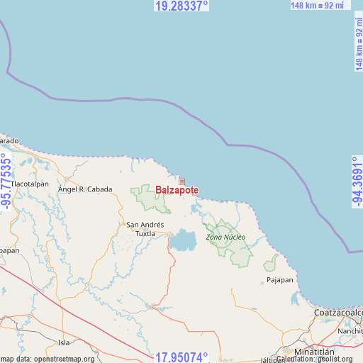
Balzapote GPS coordinates[2]
18° 37' 6.096" North, 95° 4' 19.992" West
| Map corner | latitude | longitude |
|---|---|---|
| Upper-left | 19.28337°, | -95.77535° |
| Center: | 18.61836°, | -95.07222° |
| Lower-right: | 17.95074°, | -94.3691° |
| Map W x H: | 148.2×148.2 km | = 92.1×92.1mi |
| max Lat: | 32.7° ⇑71.2% North |
| Balzapote: | 18.61836° |
| min Lat: | ⇓28.8% South 14.53588° |
| min Long | Balzapote | max Long |
| -117.105° | -95.07222° | -86.73105° |
| W 84.4%⇐ | ⇒15.6% E |
Elevation
Elevation of Balzapote is 19 m = 62 ft, and this is 1234.7 m = 4051 ft below average elevation for this country.
| Max E: |
3497 m = 11473 ft | 92.1% |
| Avg. | 1253.7 m = 4113 ft | |
| Balzapote | 19 m = 62 ft | |
Min E: |
-1 m = -3 ft | 7.9% |
See also: Mexico elevation on elevation.city.
Geographical zone
Balzapote is located in North Torrid zone (between Equator and Tropic of Cancer). Distance of this Northern Tropic circle is 535.8 km =332.9 mi to North.| Distance of | km | miles | from Balzapote |
|---|---|---|---|
| North Pole | 7936.9 | 4931.8 | to North |
| Arctic Circle | 5331 | 3312.5 | to North |
| Tropic Cancer | 535.8 | 332.9 | to North |
| Equator | 2070.2 | 1286.4 | to South |


Nearby cities:
15 places around Balzapote: (largest is in red/bold)
• Calería
23.8 km =14.8 mi,  207°
207°
• Catemaco
22.3 km =13.9 mi,  191°
191°
• Costa de Oro
13.5 km =8.4 mi,  305°
305°
• Coxcoapan
16.7 km =10.4 mi,  149°
149°
• Dos Amates
14.1 km =8.8 mi,  174°
174°
• La Nueva Victoria
20 km =12.4 mi,  282°
282°
• La Palma
6.7 km =4.2 mi, 172°
• Mario Sauza
10.9 km =6.8 mi,  180°
180°
• Matacapan
22.7 km =14.1 mi, 205°
• Salinas Roca Partida
20.1 km =12.5 mi,  297°
297°
• San Andrés Tuxtla
24 km =14.9 mi,  218°
218°
• Santa Rosa Abata
20.1 km =12.5 mi, 210°
• Sihuapan
23.1 km =14.4 mi, 208°
• Sontecomapan
13.4 km =8.3 mi,  163°
163°
• Tonalapan
22.8 km =14.2 mi, 223°
Sources, notices
• [Note1] Compared only with cities in Mexico existing in our database
• [Src1] Map data: © OpenStreetMap contributors (CC-BY-SA)
• [Src2] Other city data from geonames.org with taken over terms of usage.
• [Src3] Geographical zone / Annual Mean Temperature by Robert A. Rohde @ Wikipedia
