Tapalapan geodata
Tapalapan (Veracruz) is a populated place; located in Mexico in America/Mexico_City (GMT-6) time zone. With population of 2,354 people, there are 3753 cities with bigger population in this country. Compared to other cities in Mexico, 72.2% of cities are located further ↑North; 83.6% of cities are located further ←West and 73.1% of cities have higher elevation than Tapalapan. Note1


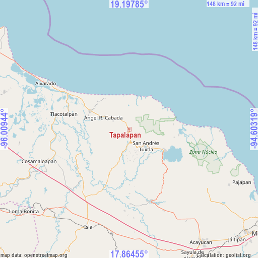
Tapalapan GPS coordinates[2]
18° 31' 57" North, 95° 18' 22.716" West
| Map corner | latitude | longitude |
|---|---|---|
| Upper-left | 19.19785°, | -96.00944° |
| Center: | 18.5325°, | -95.30631° |
| Lower-right: | 17.86455°, | -94.60319° |
| Map W x H: | 148.2×148.3 km | = 92.1×92.1mi |
| max Lat: | 32.7° ⇑72.2% North |
| Tapalapan: | 18.5325° |
| min Lat: | ⇓27.8% South 14.53588° |
| min Long | Tapalapan | max Long |
| -117.105° | -95.30631° | -86.73105° |
| W 83.6%⇐ | ⇒16.4% E |
Elevation
Elevation of Tapalapan is 283 m = 928 ft, and this is 970.7 m = 3185 ft below average elevation for this country.
| Max E: |
3497 m = 11473 ft | 73.1% |
| Avg. | 1253.7 m = 4113 ft | |
| Tapalapan | 283 m = 928 ft | |
Min E: |
-1 m = -3 ft | 26.9% |
See also: Mexico elevation on elevation.city.
Geographical zone
Tapalapan is located in North Torrid zone (between Equator and Tropic of Cancer). Distance of this Northern Tropic circle is 545.3 km =338.8 mi to North.| Distance of | km | miles | from Tapalapan |
|---|---|---|---|
| North Pole | 7946.4 | 4937.7 | to North |
| Arctic Circle | 5340.6 | 3318.5 | to North |
| Tropic Cancer | 545.3 | 338.8 | to North |
| Equator | 2060.6 | 1280.4 | to South |


Nearby cities:
15 places around Tapalapan: (largest is in red/bold)
• Buenos Aires
9.7 km =6 mi,  141°
141°
• Chonegal
10.3 km =6.4 mi,  297°
297°
• El Polvorín
11.4 km =7.1 mi,  156°
156°
• Los Lirios
9.3 km =5.8 mi,  247°
247°
• Paso del Ingenio
9.9 km =6.2 mi,  322°
322°
• Popoctepetl
2.4 km =1.5 mi,  204°
204°
• San Isidro Xoteapan (San Isidro Texcaltitán)
10.2 km =6.3 mi,  134°
134°
• Santiago Tuxtla
7.4 km =4.6 mi,  175°
175°
• Sinapan
1.4 km =0.9 mi,  79°
79°
• Tecolapan
5.5 km =3.4 mi, 320°
• Tetax Sesecapan
10 km =6.2 mi,  170°
170°
• Texcaltitán Xoteapan (Texcaltitán)
11.1 km =6.9 mi,  149°
149°
• Tonalapan
11.6 km =7.2 mi, 128°
• Tula
9.6 km =6 mi,  309°
309°
• Xoteapan
11.7 km =7.3 mi, 158°
Sources, notices
• [Note1] Compared only with cities in Mexico existing in our database
• [Src1] Map data: © OpenStreetMap contributors (CC-BY-SA)
• [Src2] Other city data from geonames.org with taken over terms of usage.
• [Src3] Geographical zone / Annual Mean Temperature by Robert A. Rohde @ Wikipedia
