San Leopoldo geodata
San Leopoldo (Veracruz) is a populated place; located in Mexico in America/Mexico_City (GMT-6) time zone. With population of 542 people, there are 15673 cities with bigger population in this country. Compared to other cities in Mexico, 74% of cities are located further ↑North; 83.5% of cities are located further ←West and 80.7% of cities have higher elevation than San Leopoldo. Note1


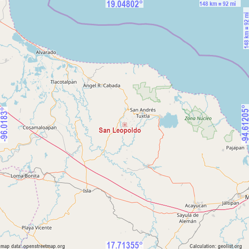
San Leopoldo GPS coordinates[2]
18° 22' 55.488" North, 95° 18' 54.612" West
| Map corner | latitude | longitude |
|---|---|---|
| Upper-left | 19.04802°, | -96.0183° |
| Center: | 18.38208°, | -95.31517° |
| Lower-right: | 17.71355°, | -94.61205° |
| Map W x H: | 148.4×148.4 km | = 92.2×92.2mi |
| max Lat: | 32.7° ⇑74% North |
| San Leopoldo: | 18.38208° |
| min Lat: | ⇓26% South 14.53588° |
| min Long | San Leopoldo | max Long |
| -117.105° | -95.31517° | -86.73105° |
| W 83.5%⇐ | ⇒16.5% E |
Elevation
Elevation of San Leopoldo is 85 m = 279 ft, and this is 1168.7 m = 3834 ft below average elevation for this country.
| Max E: |
3497 m = 11473 ft | 80.7% |
| Avg. | 1253.7 m = 4113 ft | |
| San Leopoldo | 85 m = 279 ft | |
Min E: |
-1 m = -3 ft | 19.3% |
See also: Mexico elevation on elevation.city.
Geographical zone
San Leopoldo is located in North Torrid zone (between Equator and Tropic of Cancer). Distance of this Northern Tropic circle is 562 km =349.2 mi to North.| Distance of | km | miles | from San Leopoldo |
|---|---|---|---|
| North Pole | 7963.2 | 4948.1 | to North |
| Arctic Circle | 5357.3 | 3328.9 | to North |
| Tropic Cancer | 562 | 349.2 | to North |
| Equator | 2043.9 | 1270 | to South |


Nearby cities:
15 places around San Leopoldo: (largest is in red/bold)
• Axochío
2 km =1.2 mi,  125°
125°
• Benito Juárez
5.8 km =3.6 mi,  53°
53°
• La Redonda
6.4 km =4 mi,  162°
162°
• Los Mérida
4.2 km =2.6 mi,  93°
93°
• Maxyapán
1.7 km =1.1 mi,  350°
350°
• Ocelota
3.9 km =2.4 mi,  60°
60°
• Ohuilapam
6 km =3.7 mi,  68°
68°
• Ojo de Agua
5.7 km =3.5 mi,  260°
260°
• Rincón de Zapatero
5.2 km =3.2 mi,  251°
251°
• Sehualaca
5 km =3.1 mi, 350°
• Sesecapan
3.7 km =2.3 mi,  28°
28°
• Soyata
3.8 km =2.4 mi,  112°
112°
• Texcochapan de Abajo
4 km =2.5 mi,  15°
15°
• Tilapan
3.9 km =2.4 mi,  200°
200°
• Vista Hermosa
5 km =3.1 mi, 354°
Sources, notices
• [Note1] Compared only with cities in Mexico existing in our database
• [Src1] Map data: © OpenStreetMap contributors (CC-BY-SA)
• [Src2] Other city data from geonames.org with taken over terms of usage.
• [Src3] Geographical zone / Annual Mean Temperature by Robert A. Rohde @ Wikipedia
