Ocelota geodata
Ocelota (Veracruz) is a populated place; located in Mexico in America/Mexico_City (GMT-6) time zone. With population of 1,330 people, there are 6531 cities with bigger population in this country. Compared to other cities in Mexico, 73.8% of cities are located further ↑North; 83.7% of cities are located further ←West and 78.6% of cities have higher elevation than Ocelota. Note1


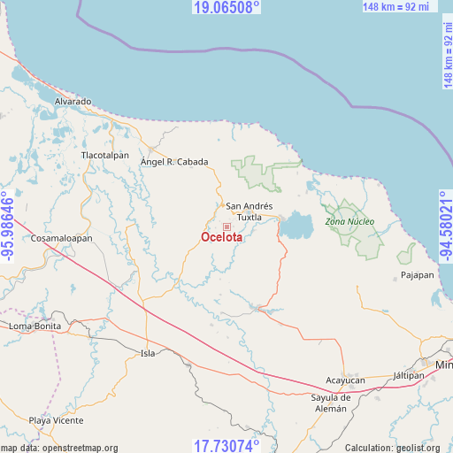
Ocelota GPS coordinates[2]
18° 23' 57.12" North, 95° 16' 59.988" West
| Map corner | latitude | longitude |
|---|---|---|
| Upper-left | 19.06508°, | -95.98646° |
| Center: | 18.3992°, | -95.28333° |
| Lower-right: | 17.73074°, | -94.58021° |
| Map W x H: | 148.4×148.4 km | = 92.2×92.2mi |
| max Lat: | 32.7° ⇑73.8% North |
| Ocelota: | 18.3992° |
| min Lat: | ⇓26.2% South 14.53588° |
| min Long | Ocelota | max Long |
| -117.105° | -95.28333° | -86.73105° |
| W 83.7%⇐ | ⇒16.3% E |
Elevation
Elevation of Ocelota is 118 m = 387 ft, and this is 1135.7 m = 3726 ft below average elevation for this country.
| Max E: |
3497 m = 11473 ft | 78.6% |
| Avg. | 1253.7 m = 4113 ft | |
| Ocelota | 118 m = 387 ft | |
Min E: |
-1 m = -3 ft | 21.4% |
See also: Mexico elevation on elevation.city.
Geographical zone
Ocelota is located in North Torrid zone (between Equator and Tropic of Cancer). Distance of this Northern Tropic circle is 560.1 km =348 mi to North.| Distance of | km | miles | from Ocelota |
|---|---|---|---|
| North Pole | 7961.3 | 4946.9 | to North |
| Arctic Circle | 5355.4 | 3327.7 | to North |
| Tropic Cancer | 560.1 | 348 | to North |
| Equator | 2045.8 | 1271.2 | to South |


Nearby cities:
15 places around Ocelota: (largest is in red/bold)
• Axochío
3.5 km =2.2 mi,  209°
209°
• Benito Juárez
2 km =1.2 mi,  41°
41°
• Cerro Amarillo de Abajo
4 km =2.5 mi,  57°
57°
• Cerro Amarillo de Arriba
5.1 km =3.2 mi, 57°
• El Polvorín
4.8 km =3 mi,  25°
25°
• Los Mérida
2.3 km =1.4 mi,  159°
159°
• Maxyapán
3.6 km =2.2 mi,  267°
267°
• Ohuilapam
2.2 km =1.4 mi,  81°
81°
• San Leopoldo
3.9 km =2.4 mi,  240°
240°
• Sesecapan
2.1 km =1.3 mi,  310°
310°
• Soyata
3.4 km =2.1 mi,  178°
178°
• Texalpan de Abajo
4.3 km =2.7 mi, 42°
• Texcochapan de Abajo
3 km =1.9 mi, 309°
• Vista Hermosa
4.9 km =3 mi, 308°
• Xoteapan
4.3 km =2.7 mi,  24°
24°
Sources, notices
• [Note1] Compared only with cities in Mexico existing in our database
• [Src1] Map data: © OpenStreetMap contributors (CC-BY-SA)
• [Src2] Other city data from geonames.org with taken over terms of usage.
• [Src3] Geographical zone / Annual Mean Temperature by Robert A. Rohde @ Wikipedia
