Axochío geodata
Axochío (Veracruz) is a populated place; located in Mexico in America/Mexico_City (GMT-6) time zone. With population of 1,549 people, there are 5567 cities with bigger population in this country. Compared to other cities in Mexico, 74.1% of cities are located further ↑North; 83.6% of cities are located further ←West and 80.9% of cities have higher elevation than Axochío. Note1


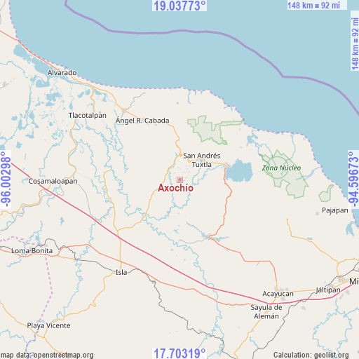
Axochío GPS coordinates[2]
18° 22' 18.3" North, 95° 17' 59.46" West
| Map corner | latitude | longitude |
|---|---|---|
| Upper-left | 19.03773°, | -96.00298° |
| Center: | 18.37175°, | -95.29985° |
| Lower-right: | 17.70319°, | -94.59673° |
| Map W x H: | 148.4×148.4 km | = 92.2×92.2mi |
| max Lat: | 32.7° ⇑74.1% North |
| Axochío: | 18.37175° |
| min Lat: | ⇓25.9% South 14.53588° |
| min Long | Axochío | max Long |
| -117.105° | -95.29985° | -86.73105° |
| W 83.6%⇐ | ⇒16.4% E |
Elevation
Elevation of Axochío is 84 m = 276 ft, and this is 1169.7 m = 3838 ft below average elevation for this country.
| Max E: |
3497 m = 11473 ft | 80.9% |
| Avg. | 1253.7 m = 4113 ft | |
| Axochío | 84 m = 276 ft | |
Min E: |
-1 m = -3 ft | 19.1% |
See also: Mexico elevation on elevation.city.
Geographical zone
Axochío is located in North Torrid zone (between Equator and Tropic of Cancer). Distance of this Northern Tropic circle is 563.2 km =350 mi to North.| Distance of | km | miles | from Axochío |
|---|---|---|---|
| North Pole | 7964.3 | 4948.8 | to North |
| Arctic Circle | 5358.4 | 3329.6 | to North |
| Tropic Cancer | 563.2 | 350 | to North |
| Equator | 2042.7 | 1269.3 | to South |


Nearby cities:
15 places around Axochío: (largest is in red/bold)
• Apixita
6.2 km =3.9 mi,  173°
173°
• Benito Juárez
5.5 km =3.4 mi,  33°
33°
• El Platanar
6.5 km =4 mi,  220°
220°
• Juan Jacobo Torres [Bodega de Totontepec]
5.7 km =3.5 mi,  133°
133°
• La Redonda
5 km =3.1 mi,  176°
176°
• Los Mérida
2.7 km =1.7 mi,  70°
70°
• Maxyapán
3.4 km =2.1 mi,  326°
326°
• Ocelota
3.5 km =2.2 mi, 29°
• Ohuilapam
5.2 km =3.2 mi,  49°
49°
• San Leopoldo
2 km =1.2 mi,  305°
305°
• Sehualaca
6.5 km =4 mi,  337°
337°
• Sesecapan
4.4 km =2.7 mi,  1°
1°
• Soyata
1.9 km =1.2 mi,  99°
99°
• Texcochapan de Abajo
5 km =3.1 mi,  353°
353°
• Tilapan
3.9 km =2.4 mi,  229°
229°
Sources, notices
• [Note1] Compared only with cities in Mexico existing in our database
• [Src1] Map data: © OpenStreetMap contributors (CC-BY-SA)
• [Src2] Other city data from geonames.org with taken over terms of usage.
• [Src3] Geographical zone / Annual Mean Temperature by Robert A. Rohde @ Wikipedia
