Villa Progreso geodata
Villa Progreso (Querétaro) is a populated place; located in Mexico in America/Mexico_City (GMT-6) time zone. With population of 5,604 people, there are 1662 cities with bigger population in this country. Compared to other cities in Mexico, 70.8% of cities are located further ↓South; 61.9% of cities are located further →East and 76% of cities have lower elevation than Villa Progreso. Note1


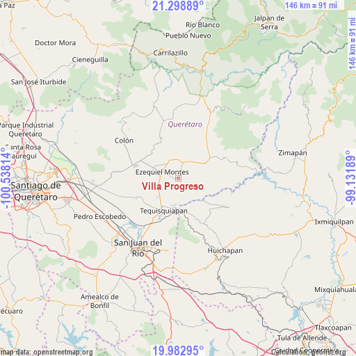
Villa Progreso GPS coordinates[2]
20° 38' 32.424" North, 99° 50' 6.036" West
| Map corner | latitude | longitude |
|---|---|---|
| Upper-left | 21.29889°, | -100.53814° |
| Center: | 20.64234°, | -99.83501° |
| Lower-right: | 19.98295°, | -99.13189° |
| Map W x H: | 146.3×146.3 km | = 90.9×90.9mi |
| max Lat: | 32.7° ⇑29.2% North |
| Villa Progreso: | 20.64234° |
| min Lat: | ⇓70.8% South 14.53588° |
| min Long | Villa Progreso | max Long |
| -117.105° | -99.83501° | -86.73105° |
| W 38.1%⇐ | ⇒61.9% E |
Elevation
Elevation of Villa Progreso is 2049 m = 6722 ft, and this is 795.3 m = 2609 ft above average elevation for this country.
| Max E: |
3497 m = 11473 ft | 24% |
| Villa Progreso | 2049 m 6722 ft | |
| Avg. | 1253.7 m = 4113 ft | |
Min E: |
-1 m = -3 ft | 76% |
See also: Mexico elevation on elevation.city.
Geographical zone
Villa Progreso is located in North Torrid zone (between Equator and Tropic of Cancer). Distance of this Northern Tropic circle is 310.7 km =193.1 mi to North.| Distance of | km | miles | from Villa Progreso |
|---|---|---|---|
| North Pole | 7711.8 | 4791.9 | to North |
| Arctic Circle | 5106 | 3172.7 | to North |
| Tropic Cancer | 310.7 | 193.1 | to North |
| Equator | 2295.2 | 1426.2 | to South |


Nearby cities:
15 places around Villa Progreso: (largest is in red/bold)
• Alfredo V. Bonfil (Los Pérez)
7.2 km =4.5 mi,  321°
321°
• Boxasní
3.5 km =2.2 mi,  335°
335°
• Boyé
10.8 km =6.7 mi,  66°
66°
• Cadereyta
6.4 km =4 mi,  17°
17°
• El Ciervo
4.7 km =2.9 mi,  235°
235°
• Ezequiel Montes
7.2 km =4.5 mi,  290°
290°
• La Nueva Unidad
3.1 km =1.9 mi,  283°
283°
• La Providencia (Las Norbertas)
5.6 km =3.5 mi, 288°
• La Purísima
8.9 km =5.5 mi, 293°
• Portezuelo
11.2 km =7 mi,  117°
117°
• Puerto de Chiquihuite
6.5 km =4 mi,  359°
359°
• Tunas Blancas
8.8 km =5.5 mi,  331°
331°
• Villa Guerrero
9.8 km =6.1 mi,  51°
51°
• Villa Nueva
3.4 km =2.1 mi,  27°
27°
• Zituní
7.9 km =4.9 mi,  4°
4°
Sources, notices
• [Note1] Compared only with cities in Mexico existing in our database
• [Src1] Map data: © OpenStreetMap contributors (CC-BY-SA)
• [Src2] Other city data from geonames.org with taken over terms of usage.
• [Src3] Geographical zone / Annual Mean Temperature by Robert A. Rohde @ Wikipedia
