San Pedro Cholula geodata
San Pedro Cholula (State of Mexico) is a populated place; located in Mexico in America/Mexico_City (GMT-6) time zone. With population of 8,941 people, there are 1063 cities with bigger population in this country. Compared to other cities in Mexico, 59.5% of cities are located further ↑North; 56.8% of cities are located further →East and 94.1% of cities have lower elevation than San Pedro Cholula. Note1


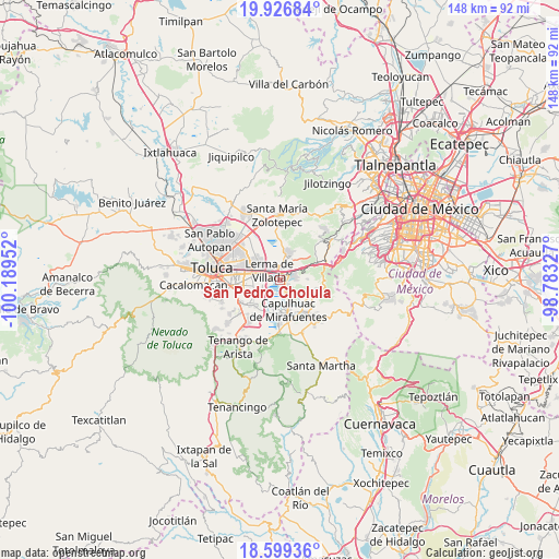
San Pedro Cholula GPS coordinates[2]
19° 15' 51.984" North, 99° 29' 11.004" West
| Map corner | latitude | longitude |
|---|---|---|
| Upper-left | 19.92684°, | -100.18952° |
| Center: | 19.26444°, | -99.48639° |
| Lower-right: | 18.59936°, | -98.78327° |
| Map W x H: | 147.6×147.6 km | = 91.7×91.7mi |
| max Lat: | 32.7° ⇑59.5% North |
| San Pedro Cholula: | 19.26444° |
| min Lat: | ⇓40.5% South 14.53588° |
| min Long | San Pedro Cholu | max Long |
| -117.105° | -99.48639° | -86.73105° |
| W 43.2%⇐ | ⇒56.8% E |
Elevation
Elevation of San Pedro Cholula is 2577 m = 8455 ft, and this is 1323.3 m = 4342 ft above average elevation for this country.
| Max E: |
3497 m = 11473 ft | 5.9% |
| San Pedro Cholula | 2577 m 8455 ft | |
| Avg. | 1253.7 m = 4113 ft | |
Min E: |
-1 m = -3 ft | 94.1% |
See also: Mexico elevation on elevation.city.
Geographical zone
San Pedro Cholula is located in North Torrid zone (between Equator and Tropic of Cancer). Distance of this Northern Tropic circle is 463.9 km =288.3 mi to North.| Distance of | km | miles | from San Pedro Cholula |
|---|---|---|---|
| North Pole | 7865.1 | 4887.1 | to North |
| Arctic Circle | 5259.2 | 3267.9 | to North |
| Tropic Cancer | 463.9 | 288.3 | to North |
| Equator | 2142 | 1331 | to South |


Nearby cities:
15 places around San Pedro Cholula: (largest is in red/bold)
• Amomolulco
2.4 km =1.5 mi,  353°
353°
• Colonia Juárez
3.1 km =1.9 mi,  41°
41°
• Colonia el Pirame
3 km =1.9 mi,  149°
149°
• El Llano del Compromiso
1.3 km =0.8 mi,  144°
144°
• El Pedregal de Guadalupe Hidalgo
2.6 km =1.6 mi,  120°
120°
• Fraccionamiento y Club de Golf los Encinos
2.8 km =1.7 mi,  13°
13°
• Lerma de Villada
3.8 km =2.4 mi,  315°
315°
• Loma Bonita
4.1 km =2.5 mi,  91°
91°
• Loma de los Esquiveles
3.7 km =2.3 mi, 89°
• Nueva Ameyalco
4.2 km =2.6 mi,  332°
332°
• Ocoyoacac
3.1 km =1.9 mi,  75°
75°
• San Antonio el Llanito
1.7 km =1.1 mi, 328°
• San Pedro Chochula
0.1 km =0.1 mi, 151°
• San Pedro Tultepec
2.4 km =1.5 mi,  271°
271°
• Texcalpa (Ex-Hacienda Texcalpa)
3.2 km =2 mi,  97°
97°
Sources, notices
• [Note1] Compared only with cities in Mexico existing in our database
• [Src1] Map data: © OpenStreetMap contributors (CC-BY-SA)
• [Src2] Other city data from geonames.org with taken over terms of usage.
• [Src3] Geographical zone / Annual Mean Temperature by Robert A. Rohde @ Wikipedia
