La Marquesa geodata
La Marquesa (Morelos) is a populated place; located in Mexico in America/Mexico_City (GMT-6) time zone. With population of 981 people, there are 8862 cities with bigger population in this country. Compared to other cities in Mexico, 58.8% of cities are located further ↑North; 55.2% of cities are located further →East and 99.8% of cities have lower elevation than La Marquesa. Note1


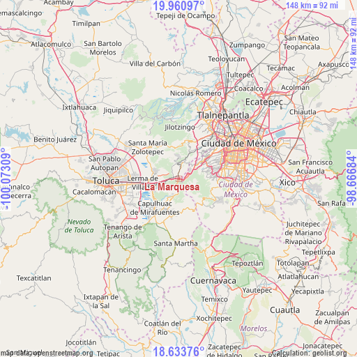
La Marquesa GPS coordinates[2]
19° 17' 55.356" North, 99° 22' 11.856" West
| Map corner | latitude | longitude |
|---|---|---|
| Upper-left | 19.96097°, | -100.07309° |
| Center: | 19.29871°, | -99.36996° |
| Lower-right: | 18.63376°, | -98.66684° |
| Map W x H: | 147.6×147.6 km | = 91.7×91.7mi |
| max Lat: | 32.7° ⇑58.8% North |
| La Marquesa: | 19.29871° |
| min Lat: | ⇓41.2% South 14.53588° |
| min Long | La Marquesa | max Long |
| -117.105° | -99.36996° | -86.73105° |
| W 44.8%⇐ | ⇒55.2% E |
Elevation
Elevation of La Marquesa is 3035 m = 9957 ft, and this is 1781.3 m = 5844 ft above average elevation for this country.
| Max E: |
3497 m = 11473 ft | 0.2% |
| La Marquesa | 3035 m 9957 ft | |
| Avg. | 1253.7 m = 4113 ft | |
Min E: |
-1 m = -3 ft | 99.8% |
See also: Mexico elevation on elevation.city.
Geographical zone
La Marquesa is located in North Torrid zone (between Equator and Tropic of Cancer). Distance of this Northern Tropic circle is 460.1 km =285.9 mi to North.| Distance of | km | miles | from La Marquesa |
|---|---|---|---|
| North Pole | 7861.2 | 4884.7 | to North |
| Arctic Circle | 5255.4 | 3265.6 | to North |
| Tropic Cancer | 460.1 | 285.9 | to North |
| Equator | 2145.8 | 1333.3 | to South |


Nearby cities:
15 places around La Marquesa: (largest is in red/bold)
• Colonia La Venta
7.3 km =4.5 mi,  56°
56°
• Cruz Blanca
5.4 km =3.4 mi,  65°
65°
• El Cerrito
6.7 km =4.2 mi,  19°
19°
• El Laurel
6.3 km =3.9 mi,  3°
3°
• El Mirasol
7 km =4.3 mi,  34°
34°
• El Palacio
6 km =3.7 mi,  13°
13°
• Huixquilucan
7.1 km =4.4 mi, 16°
• Huixquilucan de Degollado
7.2 km =4.5 mi, 17°
• Ignacio Allende
5.1 km =3.2 mi, 9°
• Piedra Grande
6.1 km =3.8 mi,  341°
341°
• Salazar
2.2 km =1.4 mi,  296°
296°
• San Jerónimo Acazulco
6.1 km =3.8 mi,  232°
232°
• San Juan Yautepec
6.4 km =4 mi, 29°
• San Lorenzo Acopilco
5.7 km =3.5 mi,  52°
52°
• San Pedro Atlapulco
6.6 km =4.1 mi,  203°
203°
Sources, notices
• [Note1] Compared only with cities in Mexico existing in our database
• [Src1] Map data: © OpenStreetMap contributors (CC-BY-SA)
• [Src2] Other city data from geonames.org with taken over terms of usage.
• [Src3] Geographical zone / Annual Mean Temperature by Robert A. Rohde @ Wikipedia
