Pérez de Galeana geodata
Pérez de Galeana (Morelos) is a populated place; located in Mexico in America/Mexico_City (GMT-6) time zone. With population of 1,844 people, there are 4710 cities with bigger population in this country. Compared to other cities in Mexico, 56.6% of cities are located further ↓South; 51.7% of cities are located further →East and 85.9% of cities have lower elevation than Pérez de Galeana. Note1


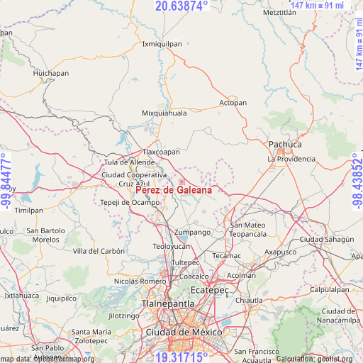
Pérez de Galeana GPS coordinates[2]
19° 58' 45.588" North, 99° 8' 29.904" West
| Map corner | latitude | longitude |
|---|---|---|
| Upper-left | 20.63874°, | -99.84477° |
| Center: | 19.97933°, | -99.14164° |
| Lower-right: | 19.31715°, | -98.43852° |
| Map W x H: | 146.9×146.9 km | = 91.3×91.3mi |
| max Lat: | 32.7° ⇑43.4% North |
| Pérez de Galeana: | 19.97933° |
| min Lat: | ⇓56.6% South 14.53588° |
| min Long | Pérez de Galea | max Long |
| -117.105° | -99.14164° | -86.73105° |
| W 48.3%⇐ | ⇒51.7% E |
Elevation
Elevation of Pérez de Galeana is 2279 m = 7477 ft, and this is 1025.3 m = 3364 ft above average elevation for this country.
| Max E: |
3497 m = 11473 ft | 14.1% |
| Pérez de Galeana | 2279 m 7477 ft | |
| Avg. | 1253.7 m = 4113 ft | |
Min E: |
-1 m = -3 ft | 85.9% |
See also: Mexico elevation on elevation.city.
Geographical zone
Pérez de Galeana is located in North Torrid zone (between Equator and Tropic of Cancer). Distance of this Northern Tropic circle is 384.4 km =238.9 mi to North.| Distance of | km | miles | from Pérez de Galeana |
|---|---|---|---|
| North Pole | 7785.6 | 4837.7 | to North |
| Arctic Circle | 5179.7 | 3218.5 | to North |
| Tropic Cancer | 384.4 | 238.9 | to North |
| Equator | 2221.5 | 1380.4 | to South |


Nearby cities:
15 places around Pérez de Galeana: (largest is in red/bold)
• Apaxco de Ocampo
3.1 km =1.9 mi,  261°
261°
• Atotonilco de Tula
8.6 km =5.3 mi,  291°
291°
• Colonia 3 de Mayo (La Cruz)
2.3 km =1.4 mi,  274°
274°
• Colonia Ermita
7 km =4.3 mi,  234°
234°
• Colonia Guadalupe los Manantiales
8.6 km =5.3 mi,  87°
87°
• Colonia Juárez
2 km =1.2 mi,  336°
336°
• Colonia el Pixquay (Colonia el Carmen)
5.2 km =3.2 mi,  250°
250°
• Coyotillos
2.9 km =1.8 mi,  322°
322°
• El Refugio
5.6 km =3.5 mi,  300°
300°
• Santa María Ajoloapan
10.1 km =6.3 mi, 91°
• Santa María Apaxco
5.4 km =3.4 mi,  240°
240°
• Tequixquiac
7.8 km =4.8 mi,  182°
182°
• Texas
7.6 km =4.7 mi,  312°
312°
• Tlapanaloya
6.7 km =4.2 mi,  135°
135°
• Vito
6.1 km =3.8 mi,  281°
281°
Sources, notices
• [Note1] Compared only with cities in Mexico existing in our database
• [Src1] Map data: © OpenStreetMap contributors (CC-BY-SA)
• [Src2] Other city data from geonames.org with taken over terms of usage.
• [Src3] Geographical zone / Annual Mean Temperature by Robert A. Rohde @ Wikipedia
