Texas geodata
Texas (Hidalgo) is a populated place; located in Mexico in America/Mexico_City (GMT-6) time zone. With population of 993 people, there are 8774 cities with bigger population in this country. Compared to other cities in Mexico, 57.5% of cities are located further ↓South; 52.7% of cities are located further →East and 81.5% of cities have lower elevation than Texas. Note1


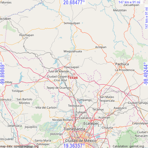
Texas GPS coordinates[2]
20° 1' 32.016" North, 99° 11' 44.016" West
| Map corner | latitude | longitude |
|---|---|---|
| Upper-left | 20.68477°, | -99.89869° |
| Center: | 20.02556°, | -99.19556° |
| Lower-right: | 19.36357°, | -98.49244° |
| Map W x H: | 146.9×146.9 km | = 91.3×91.3mi |
| max Lat: | 32.7° ⇑42.5% North |
| Texas: | 20.02556° |
| min Lat: | ⇓57.5% South 14.53588° |
| min Long | Texas | max Long |
| -117.105° | -99.19556° | -86.73105° |
| W 47.3%⇐ | ⇒52.7% E |
Elevation
Elevation of Texas is 2176 m = 7139 ft, and this is 922.3 m = 3026 ft above average elevation for this country.
| Max E: |
3497 m = 11473 ft | 18.5% |
| Texas | 2176 m 7139 ft | |
| Avg. | 1253.7 m = 4113 ft | |
Min E: |
-1 m = -3 ft | 81.5% |
See also: Mexico elevation on elevation.city.
Geographical zone
Texas is located in North Torrid zone (between Equator and Tropic of Cancer). Distance of this Northern Tropic circle is 379.3 km =235.7 mi to North.| Distance of | km | miles | from Texas |
|---|---|---|---|
| North Pole | 7780.4 | 4834.5 | to North |
| Arctic Circle | 5174.5 | 3215.3 | to North |
| Tropic Cancer | 379.3 | 235.7 | to North |
| Equator | 2226.6 | 1383.5 | to South |


Nearby cities:
15 places around Texas: (largest is in red/bold)
• Apaxco de Ocampo
6.2 km =3.9 mi,  155°
155°
• Atitalaquia
4.7 km =2.9 mi,  324°
324°
• Atotonilco de Tula
3.1 km =1.9 mi,  229°
229°
• Cardonal
5 km =3.1 mi,  313°
313°
• Cañada
5.5 km =3.4 mi,  236°
236°
• Colonia 3 de Mayo (La Cruz)
6 km =3.7 mi,  146°
146°
• Colonia Juárez
5.8 km =3.6 mi,  124°
124°
• Coyotillos
4.8 km =3 mi,  126°
126°
• El Refugio
2.4 km =1.5 mi, 161°
• Ocampo
4.9 km =3 mi,  247°
247°
• Progreso
4.5 km =2.8 mi,  261°
261°
• Tezoquipa
3.6 km =2.2 mi,  344°
344°
• Tlamaco (San Gerónimo Tlamaco)
3.7 km =2.3 mi,  286°
286°
• Unidad Habitacional Antonio Osorio de León (Bojay)
5.5 km =3.4 mi, 291°
• Vito
4 km =2.5 mi,  185°
185°
Sources, notices
• [Note1] Compared only with cities in Mexico existing in our database
• [Src1] Map data: © OpenStreetMap contributors (CC-BY-SA)
• [Src2] Other city data from geonames.org with taken over terms of usage.
• [Src3] Geographical zone / Annual Mean Temperature by Robert A. Rohde @ Wikipedia
